Area Overview for E5 0UN
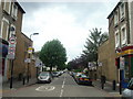
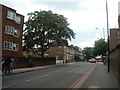
Photos of E5 0UN


Area Information
E5 0UN is a small residential postcode area in England, home to 1,593 residents. It is a compact cluster of properties, predominantly houses, catering to a mature population. The median age of 47 suggests a community of middle-aged adults, many in their 30s to 60s, with a strong presence of families and long-term residents. Daily life here is shaped by proximity to transport hubs and local amenities, offering a balance between suburban tranquility and urban accessibility. The area’s small size means it is likely to have a tight-knit feel, though its immediate surroundings provide a range of services. With excellent broadband connectivity and a mix of rail, metro, and ferry options, residents can easily navigate to nearby cities or suburbs. While the population is relatively small, the area’s strategic location near major transport arteries ensures it is not isolated. For those seeking a place with practical connectivity and a stable demographic, E5 0UN offers a straightforward, no-frills living environment.
- Area Type
- Postcode
- Area Size
- Not available
- Population
- 1593
- Population Density
- 17583 people/km²
The property market in E5 0UN is characterised by a predominance of houses, with 43% of residents owning their homes. This suggests a mix of owner-occupied properties and rental stock, though the small size of the area means the housing stock is limited. The focus on houses, rather than flats or apartments, may appeal to buyers seeking larger living spaces or families requiring more room. However, the relatively low home ownership rate indicates that a significant portion of the population rents, which could influence local property prices and availability. Given the area’s compact nature, buyers should consider nearby suburbs for a broader range of options. The market is likely to be competitive for those seeking to purchase, with limited inventory. For renters, the mix of ownership and rental properties may provide some stability, though the area’s small size could limit choice.
House Prices in E5 0UN
No properties found in this postcode.
Energy Efficiency in E5 0UN
Living in E5 0UN offers access to a range of amenities within walking or short transit distance. Local shops include Spar, Co-op Hackney, and Co-op Clapton, providing essentials for daily life. The area’s proximity to rail, metro, and ferry services ensures easy access to larger retail and dining hubs. For commuters, stations like Hackney Central and Hackney Wick link to London’s broader transport network, while ferry piers such as Canary Wharf Pier connect to the Thames. The presence of London City Airport nearby adds to the area’s accessibility. While the immediate vicinity lacks large parks or leisure facilities, the surrounding area likely offers green spaces and recreational opportunities. The mix of retail, transport, and travel options creates a practical, convenience-focused lifestyle, ideal for those who value accessibility over expansive local amenities.
Amenities
Schools
| Rank | School | Type | Entry gender | Ages |
|---|
Explore more schools in this area
Go to Schools tabDemographics
The population of E5 0UN is predominantly adults aged 30–64, with a median age of 47. This suggests a community of established professionals, families, and retirees, many of whom may have lived in the area for years. Home ownership rates stand at 43%, indicating a mix of owner-occupied properties and rental units. The accommodation type is primarily houses, which may appeal to those seeking more space than flats. The predominant ethnic group is White, though specific diversity statistics are not provided. The age profile implies a stable, low-turnover population, which can contribute to a sense of continuity. However, the relatively low home ownership rate may reflect a reliance on rental housing, potentially affecting the local property market’s dynamics. The absence of detailed deprivation data means the area’s socioeconomic challenges cannot be fully assessed, but the age and housing data suggest a community focused on long-term stability rather than rapid change.
Household Size
Accommodation Type
Tenure
Ethnic Group
Religion
Household Composition
Age
Household Deprivation
NS-SEC
Explore more demographic insights in this area
Go to Demographics tabPlanning
Planning Constraints
- Flood RiskPremium
- Ramsar Wetland SitesPremium
- Area of Outstanding Natural BeautyPremium
- Protected Nature ReservePremium
- Protected WoodlandPremium
- Crime RiskPremium