Area Overview for E18 1AU
Photos of E18 1AU


Area Information
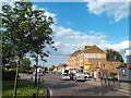
Living in E18 1AU means residing within a specific postcode area covering a small residential cluster of 256 m². You are part of a compact community with a population of 1719 people. This high density is found on a very small land area. The location offers a contained environment where daily life is centred around nearby transport hubs and local services. You find yourself in England where the immediate surroundings determine your routine. The area functions as a quiet residential pocket rather than a sprawling suburb. Residents navigate a tight-knit neighbourhood where everyone is potentially within walking distance of essential amenities. The small physical footprint means that the cluster feels distinct from the wider urban sprawl of East London. You can expect a lived-in feel defined by its residential focus. Access to stations like Snaresbrook and Wanstead places you immediately on the tube network. The postcode E18 1AU serves as the gateway to this specific slice of local life. Your daily commute starts and ends within a defined, manageable geographic zone. This structure supports a lifestyle anchored by proximity to transport and retail. You do not need to travel far for most daily necessities. The area maintains its identity as a focused residential cluster.
- Area Type
- Postcode
- Area Size
- 256 m²
- Population
- 1719
- Population Density
- 7805 people/km²
The property market in E18 1AU is defined by a preference for flats within a compact residential cluster. With 53% of the population owning their homes, you will find a substantial base of owner-occupiers in this postcode area. The predominant accommodation type is flats, which aligns with the high-density nature of the 256 m² zone. This mix suggests a market where smaller urban dwellings meet the needs of established residents. You are looking at an area where two-thirds of households do not own their properties. This indicates a significant rental sector operates alongside the owner-occupied stock. The ratio implies that if you are buying, competition may be higher among those seeking specific flat units. The total population of 1719 resides in this small footprint, meaning every property sale impacts the local market noticeably. Flats in E18 1AU offer a specific entry point into the London housing market. Buyers here typically seek convenience over large gardens or ground space. The high population density supports values consistent with urban living standards. You should factor in the scarcity of space as a primary cost driver. The market reflects the practical needs of a community centred on adults aged 30 to 64. Ownership rates show confidence in these specific flats despite high density. Prices will reflect the premium for location and the convenience of the site.
House Prices in E18 1AU
Showing 1 properties
| Address | Type | Beds | Baths | Last Sale Price | Last Sale Date | |
|---|---|---|---|---|---|---|
| 123A George Lane, South Woodford, London, E18 1AU | Flat | - | - | - | - |
Energy Efficiency in E18 1AU
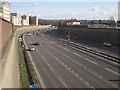
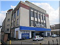
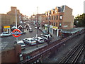
Your lifestyle in E18 1AU benefits from immediate access to major transport hubs and retail chains. South Woodford, Snaresbrook Station, and Wanstead Station provide easy rail connections. You can reach Wood Street Station, Highams Park Station, and Walthamstow Central Station for wider network access. Local retail options include Sainsburys South and Co-op South for your grocery needs. M & S South Woodford SF is also within practical reach. The Whipps Cross Bus Interchange offers additional bus connectivity to surrounding districts. For leisure, you are close to the park area near East India Pier, accessible by water link. London City Airport sits nearby, making business travel convenient. The proximity to these stations means you do not need to drive for commuting. Shops and supermarkets are accessible within the immediate residential cluster. You can access public transport from your doorstep in this high-density area. The presence of multiple stations gives you flexibility in your daily commute choices. Retail options ensure you can pick up weekly essentials without leaving the neighbourhood. The bus interchange expands your journey options beyond the rail network. The airport proximity adds value for business professionals living here. Your daily routine integrates seamlessly with these amenities. You live in an area where essential services are never far away.
Amenities
Schools
One independent school serves the needs of families near E18 1AU: Snaresbrook Prep School. This institution stands out as the primary listed educational option for the residential cluster. As an independent school, it offers a private education alternative to the state sector. The presence of this school caters to families who have chosen a private route for their children. You will find no state primary or secondary schools explicitly listed in the immediate vicinity of this postcode. The choice of Snaresbrook Prep School suggests a community that values private education options. The proximity of this independent school provides a direct route to schooling for residents of E18 1AU. Parents considering moving here must weigh the commute time to this specific school against other options in the wider borough. The single named school indicates a potentially limited choice for those strictly attached to this postcode. Families may look beyond the immediate 256 m² boundary for additional educational provisions. The independent status of the school means fees apply, which affects feasibility for the general population. However, it provides a secure option for those requiring that specific type of education. The area relies heavily on this one named institution for its educational landscape.
| Rank | School | Type | Entry gender | Ages |
|---|
Explore more schools in this area
Go to Schools tabDemographics
The community in E18 1AU consists primarily of adults aged between 30 and 64 years. You will find that the median age in the area is 47 years. This age profile suggests a neighbourhood settled by families and long-term residents rather than students or young professionals. Over 53% of residents own their homes, indicating a stable, owner-occupied demographic. The majority of people living here reside in flats rather than detached houses. This housing style suits the density of the 256 m² postcode cluster. White people form the predominant ethnic group within this residential cluster. The population density is extremely high, measuring at 6726157 people per km² based on the available data. This figure reflects the concentration of 1719 people in the specific postcode E18 1AU. You can expect a community composed mostly of established households. The accommodation type is heavily weighted towards flats, which aligns with the urban nature of the location. Ownership levels suggest a significant number of people have a financial stake in their local environment. The age range of 30 to 64 also implies a workforce population likely engaged in full-time employment. Your neighbours are likely peers who value stability in their living situation.
Household Size
Accommodation Type
Tenure
Ethnic Group
Religion
Household Composition
Age
Household Deprivation
NS-SEC
Explore more demographic insights in this area
Go to Demographics tabPlanning
Planning Constraints
- Flood RiskPremium
- Ramsar Wetland SitesPremium
- Area of Outstanding Natural BeautyPremium
- Protected Nature ReservePremium
- Protected WoodlandPremium