Area Overview for E17 5ZE
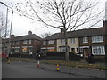
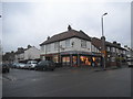
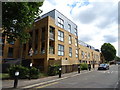
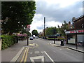
Photos of E17 5ZE


Area Information
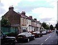
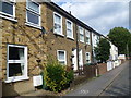
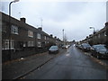
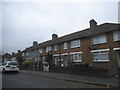
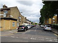
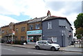
E17 5ZE is a small, tightly knit residential cluster in England with a population of 2047. It is characterised by a mature demographic, with a median age of 47 and a strong presence of adults aged 30–64. The area is predominantly flat-based, with 56% of homes owned by residents rather than rented. This suggests a stable, long-term community rather than a transient rental market. Daily life here is shaped by proximity to transport hubs and local amenities. Residents benefit from excellent broadband connectivity, scoring 100 out of 100, and mobile coverage rated 85. The area’s safety profile is strong, with a crime risk score of 77 and no flood or environmental hazards. Nearby, The Winns Primary School offers a good Ofsted-rated education for younger families. The cluster’s compact size means residents can access shops, rail, and bus services within walking or cycling distance, blending practicality with a sense of community.
- Area Type
- Postcode
- Area Size
- Not available
- Population
- Not available
- Population Density
- Not available
The property market in E17 5ZE is dominated by flats, with 56% of homes owner-occupied. This suggests a mix of long-term residents and a limited rental market, though the exact proportion of rental properties is not specified. The flat-based housing stock is typical of smaller residential clusters, offering compact living spaces that may appeal to those prioritising convenience over larger homes. The area’s small size means the housing stock is unlikely to expand significantly, which could make it a competitive market for buyers. For those seeking owner-occupied properties, the availability of flats may be more consistent than in larger, more sprawling areas. However, the lack of data on property prices or recent sales trends means buyers should consider the local supply and demand dynamics. The presence of nearby transport links may also influence property values, as accessibility is a key factor for many homebuyers.
House Prices in E17 5ZE
No properties found in this postcode.
Energy Efficiency in E17 5ZE
Living in E17 5ZE offers access to a range of amenities within practical reach. Retail options include Co-op Walthamstow, Co-op Higham, and Tesco Walthamstow, providing everyday shopping needs. The area’s rail and metro stations connect residents to broader leisure and employment opportunities. Nearby, the Whipps Cross Bus Interchange serves as a hub for local and regional travel. While no parks or leisure facilities are explicitly listed, the presence of multiple transport links and retail centres suggests a focus on convenience over expansive green spaces. The mix of shops, transport, and connectivity creates a lifestyle that balances practicality with accessibility, ideal for those prioritising ease of movement and proximity to services.
Amenities
Schools
The Winns Primary School is the only school explicitly listed near E17 5ZE, offering primary education with a good Ofsted rating. This provides a reliable option for families with young children, though no secondary schools are mentioned in the data. The presence of a single primary school suggests that parents may need to look beyond the immediate area for secondary education. The school’s rating indicates a standard of teaching and facilities that meet expectations, which is reassuring for families prioritising education. However, the absence of additional schools, such as secondary or specialist institutions, may limit choices for older children. For those seeking a full range of educational options, proximity to other schools outside E17 5ZE would be a practical consideration.
| Rank | School | Type | Entry gender | Ages |
|---|
Explore more schools in this area
Go to Schools tabDemographics
The community in E17 5ZE is predominantly composed of adults aged 30–64, reflecting a mature population with a median age of 47. Home ownership is high at 56%, indicating a stable demographic where many residents have long-term ties to the area. Accommodation is largely flat-based, which aligns with the area’s compact residential layout. The predominant ethnic group is White, though no specific data on diversity or deprivation is provided. The age profile suggests a mix of established professionals and families, with limited evidence of younger or older populations. This demographic structure may influence local services and amenities, which cater to middle-aged residents and their needs. The absence of specific data on deprivation means the area’s quality of life cannot be assessed in that context, but the safety and connectivity metrics suggest a generally stable environment.
Household Size
Accommodation Type
Tenure
Ethnic Group
Religion
Household Composition
Age
Household Deprivation
NS-SEC
Explore more demographic insights in this area
Go to Demographics tabPlanning
Planning Constraints
- Flood RiskPremium
- Ramsar Wetland SitesPremium
- Area of Outstanding Natural BeautyPremium
- Protected Nature ReservePremium
- Protected WoodlandPremium