Area Overview for E16 4DT
Photos of E16 4DT


Area Information
Living in E16 4DT means inhabiting a densely populated residential cluster in east London, where 2,671 people reside across just 1,698 square metres. This compact area is defined by its proximity to transport hubs, including Canning Town and Canary Wharf stations, and its ease of access to London City Airport. The high population density—over 1.5 million people per square kilometre—reflects a tightly knit community, though the area’s small size means amenities and services are concentrated within a short walk or journey. Daily life here is shaped by its role as a commuter node, with residents frequently moving between the area and central London. The presence of multiple retail outlets, such as Iceland Canning and Morrisons Canning, ensures basic needs are met locally, while the nearby ferry terminals offer swift connections to the Thames. E16 4DT is not a place for those seeking spacious living; its character lies in its efficiency, accessibility, and the vibrancy of its transport network.
- Area Type
- Postcode
- Area Size
- 1698 m²
- Population
- Not available
- Population Density
- Not available
E16 4DT is a rental market, with just 20% of properties owner-occupied. The accommodation type is predominantly flats, reflecting the area’s compact nature and high density. This makes it unsuitable for buyers seeking spacious, detached homes, as the housing stock is limited to smaller, shared spaces. The small area size means the property market is tightly concentrated, with limited scope for expansion or development. For buyers, this suggests that any available properties are likely to be in high demand, with competition from both local and external renters. The focus on flats also implies that the area is better suited to those prioritising affordability and convenience over private living space. Prospective buyers should consider nearby areas for more varied housing options, as E16 4DT itself offers limited scope for owner-occupation.
House Prices in E16 4DT
No properties found in this postcode.
Energy Efficiency in E16 4DT
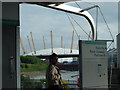
Residents of E16 4DT have access to a range of essential amenities within easy reach. Local retail options include Iceland Canning, Co-op Canning, and Morrisons Canning, ensuring daily shopping needs are met. The area’s transport links are extensive, with metro, rail, and ferry services providing seamless connections to central London and beyond. Nearby stations such as Royal Victoria and Canary Wharf Railway Station facilitate quick commutes, while London City Airport is within a short journey. The presence of multiple ferry piers, including Royal Wharf Pier, offers alternative routes along the Thames. Though the area is small, its strategic location means it serves as a gateway to broader London. The concentration of services and transport options supports a lifestyle focused on efficiency and accessibility, though the lack of green spaces or leisure facilities suggests residents may need to travel further for recreational activities.
Amenities
Schools
| Rank | School | Type | Entry gender | Ages |
|---|
Explore more schools in this area
Go to Schools tabDemographics
The community in E16 4DT is predominantly composed of adults aged 30–64, with a median age of 22, suggesting a mix of younger and older residents. Only 20% of homes are owner-occupied, indicating a rental-dominated market, with flats being the primary accommodation type. The area’s predominant ethnic group is Black residents, reflecting a diverse demographic profile. The population density of 1,573,452 people per square kilometre is exceptionally high, which can impact living conditions, such as limited private space and potential strain on local services. This density also means the area is highly utilised, with residents often relying on shared amenities and communal spaces. The combination of high density and rental focus suggests a transient population, with many residents prioritising proximity to transport and employment over long-term residency.
Household Size
Accommodation Type
Tenure
Ethnic Group
Religion
Household Composition
Age
Household Deprivation
NS-SEC
Explore more demographic insights in this area
Go to Demographics tabPlanning
Planning Constraints
- Flood RiskPremium
- Ramsar Wetland SitesPremium
- Area of Outstanding Natural BeautyPremium
- Protected Nature ReservePremium
- Protected WoodlandPremium