Area Overview for E15 1BN
Photos of E15 1BN


Area Information
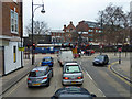
E15 1BN is a small, densely populated postcode area in England, covering just 1,596 m² and home to 1,570 residents. Its compact size and high population density of 983,500 people per km² reflect a tightly knit, urban environment. This area is defined by its proximity to Stratford, a key transport hub, and its mix of residential and commercial infrastructure. Daily life here is shaped by the surrounding connectivity, with multiple rail, metro, and ferry options within reach. The community is predominantly composed of adults aged 30–64, suggesting a mature demographic focused on stability and convenience. While the area lacks green spaces or natural landmarks, its strategic location near Stratford Station and major roads like the A13 ensures easy access to London’s broader networks. For those prioritising accessibility over open space, E15 1BN offers a compact, functional living environment with a strong emphasis on transport links and proximity to retail and educational facilities.
- Area Type
- Postcode
- Area Size
- 1596 m²
- Population
- 1570
- Population Density
- 12353 people/km²
E15 1BN is a rental-focused area, with only 26% of residents owning their homes. The accommodation type is predominantly flats, which aligns with the area’s high population density and limited space. This suggests a housing stock tailored to urban living, with a focus on efficiency rather than family homes. The small size of the postcode and the prevalence of flats indicate that property options are likely limited to smaller units, which may appeal to single occupants or couples without children. For buyers, the low home ownership rate and compact layout mean competition for available properties, particularly for those seeking owner-occupied homes. The area’s proximity to Stratford’s transport links may offset its lack of spacious housing, making it attractive to those prioritising connectivity over square footage.
House Prices in E15 1BN
Showing 3 properties
| Address | Type | Beds | Baths | Last Sale Price | Last Sale Date | |
|---|---|---|---|---|---|---|
| Flat 1, 1-141 Gerry Raffles Square, Stratford, London, E15 1BN | Flat | 2 | 2 | - | - | |
| Flat 2, 1-141 Gerry Raffles Square, Stratford, London, E15 1BN | undefined | - | - | - | - | |
| Theatre Royal, Theatre Square, Stratford, London, E15 1BN | Leisure | - | - | - | - |
Energy Efficiency in E15 1BN
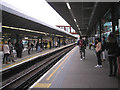
Living in E15 1BN offers a range of retail and transport amenities within walking or short transit distance. The area is served by five retail outlets, including Iceland Stratford 2, Sainsburys Stratford, and Morrisons Stratford, ensuring everyday shopping needs are met. Transport options are extensive, with five rail stations, five metro stops, and ferry access to key piers. The nearby Whipps Cross Bus Interchange and proximity to London City Airport enhance mobility. While the area lacks detailed information on parks or leisure facilities, its density and transport links suggest a focus on convenience over open space. The presence of multiple retail and transport hubs indicates a lifestyle centred on accessibility, making it suitable for those who prioritise urban connectivity over suburban tranquillity.
Amenities
Schools
Residents of E15 1BN have access to two notable educational institutions: Stratford Circus, which is categorised as ‘other’, and UK Community College, an independent school. Stratford Circus’s classification is unclear, but its presence suggests a local community-focused approach to education. UK Community College, as an independent institution, may offer specialised or private schooling options. The mix of school types provides families with a choice between public and private education, though the absence of Ofsted ratings or specific academic performance data means potential buyers must investigate further. For those prioritising school quality, the proximity of these institutions to the area’s transport hubs may facilitate commuting to other districts with more extensive educational offerings.
| Rank | School | Type | Entry gender | Ages |
|---|
Explore more schools in this area
Go to Schools tabDemographics
The population of E15 1BN is 1,570, with a median age of 47 and the majority of residents falling within the 30–64 age range. This suggests a community of established adults, many of whom may be in their peak working years. Home ownership is low, with only 26% of residents owning their homes, indicating a rental-dominated market. The primary accommodation type is flats, reflecting the area’s compact footprint and likely high-rise development. The predominant ethnic group is White, though no specific diversity statistics are provided. The high population density of 983,500 people per km² underscores the area’s intensity, which may impact living conditions and community dynamics. For buyers, this demographic profile implies a mature, stable population with established needs, though the limited home ownership rate may suggest challenges in securing long-term property investment.
Household Size
Accommodation Type
Tenure
Ethnic Group
Religion
Household Composition
Age
Household Deprivation
NS-SEC
Explore more demographic insights in this area
Go to Demographics tabPlanning
Planning Constraints
- Flood RiskPremium
- Ramsar Wetland SitesPremium
- Area of Outstanding Natural BeautyPremium
- Protected Nature ReservePremium
- Protected WoodlandPremium