Area Overview for E13 8NQ
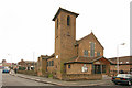
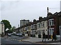
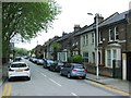
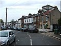
Photos of E13 8NQ


Area Information
E13 8NQ is a small, compact residential postcode in England, home to 2261 people. It is a tight-knit area where daily life is shaped by its proximity to transport hubs and local amenities. The community is predominantly composed of adults aged 30–64, with a median age of 47, suggesting a stable, mature population. While the area is small, it offers a blend of practical living with access to nearby retail, schools, and transport links. Residents benefit from low crime rates, with a safety score of 71, and no significant environmental risks such as flood zones or protected natural areas. The area’s character is defined by its residential cluster, with a focus on houses rather than high-density housing. For those seeking a quiet yet connected location, E13 8NQ provides a balance of convenience and tranquillity, with easy access to London’s broader infrastructure.
- Area Type
- Postcode
- Area Size
- Not available
- Population
- 2261
- Population Density
- 15911 people/km²
The property market in E13 8NQ is characterised by a 32% home ownership rate, which is below the national average, indicating a rental market that dominates. The area is primarily composed of houses, which is notable for a postcode of this size, suggesting a focus on single-family homes rather than apartments or flats. This housing stock may appeal to buyers seeking spacious, traditional properties, though the limited number of homes means the market is likely small and competitive. The low home ownership rate implies that many residents are renters, which could influence the availability of long-term buy-to-let opportunities. For those considering purchasing, the area’s compact nature means that properties are likely to be in close proximity to transport and amenities, offering convenience for families or commuters. However, the limited scale of the area may also mean fewer options for buyers.
House Prices in E13 8NQ
No properties found in this postcode.
Energy Efficiency in E13 8NQ
E13 8NQ offers a range of amenities within practical reach, including retail options such as Iceland (480–482, 359) and Tesco Green Gate, providing everyday shopping convenience. The area is well-served by transport, with metro, rail, and ferry connections facilitating easy movement. Residents can access London City Airport, making travel to and from the city straightforward. The presence of multiple stations and piers suggests a lifestyle centred on connectivity, ideal for commuters or those requiring regular travel. While the data does not specify parks or leisure facilities, the proximity to transport hubs and retail options implies a focus on practicality over expansive recreational spaces. The mix of retail, transport, and travel options ensures that daily life in E13 8NQ is efficient and accessible.
Amenities
Schools
The nearest school to E13 8NQ is Kaizen Primary School, which serves the local community with primary education. No further details about its Ofsted rating are available, but its presence indicates that families with young children have access to a local educational institution. The absence of secondary schools in the immediate vicinity may require students to travel to nearby areas for higher education, though the proximity to transport hubs like Plaistow and Canning Town stations could ease commuting. The single primary school suggests a focused approach to early education, but parents may need to look beyond the postcode for more comprehensive schooling options.
| Rank | School | Type | Entry gender | Ages |
|---|
Explore more schools in this area
Go to Schools tabDemographics
The population of E13 8NQ is 2261, with a median age of 47. The majority of residents fall within the 30–64 age range, indicating a community of established adults, many of whom may be in their prime working years. Home ownership in the area is relatively low at 32%, suggesting that a significant portion of the population rents their homes. The accommodation type is primarily houses, which is unusual for urban areas but aligns with the postcode’s residential cluster. The predominant ethnic group is White, though no further breakdown of diversity is provided. The absence of specific data on deprivation means no direct conclusions can be drawn about socioeconomic challenges, but the low crime score of 71 implies a generally stable environment. This demographic profile suggests a community focused on practical living, with a mix of homeowners and renters.
Household Size
Accommodation Type
Tenure
Ethnic Group
Religion
Household Composition
Age
Household Deprivation
NS-SEC
Explore more demographic insights in this area
Go to Demographics tabPlanning
Planning Constraints
- Flood RiskPremium
- Ramsar Wetland SitesPremium
- Area of Outstanding Natural BeautyPremium
- Protected Nature ReservePremium
- Protected WoodlandPremium