Area Overview for E12 6SZ
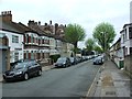
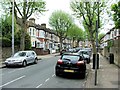
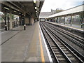
Photos of E12 6SZ


Area Information
E12 6SZ is a small residential cluster in east London with a population of 2253, reflecting a tight-knit community. The area is characterised by its modest scale, offering a mix of housing options within a compact footprint. Residents here are predominantly adults aged 30–64, with a median age of 47, suggesting a mature demographic. The area’s proximity to key transport hubs and amenities makes it practical for daily living, though its small size means it is best suited for those prioritising convenience over expansive space. The presence of primary schools, retail outlets, and multiple transport links within walking distance underscores its accessibility. While it lacks the density of larger urban centres, E12 6SZ provides a straightforward, functional living environment. Its location near London City Airport and major rail lines also positions it as a gateway to broader London, though the area itself remains focused on local needs. For buyers seeking a quiet, manageable neighbourhood with essential services nearby, E12 6SZ offers a straightforward proposition.
- Area Type
- Postcode
- Area Size
- Not available
- Population
- Not available
- Population Density
- Not available
The property market in E12 6SZ is defined by its low home ownership rate of 37%, suggesting that rental properties dominate the housing stock. The area’s accommodation type is primarily houses, which is unusual in densely populated parts of London. This mix implies a focus on single-family homes, potentially appealing to those seeking space within a compact area. However, the small size of E12 6SZ means the available housing stock is limited, and buyers may need to consider nearby areas for more options. The predominance of houses could also indicate a market skewed towards owner-occupiers who value private space, though the low home ownership rate suggests otherwise. For prospective buyers, this dynamic means competition for available properties and a need to assess whether the area’s characteristics align with long-term housing needs. The limited scale of the area also means that property values and availability are closely tied to local demand.
House Prices in E12 6SZ
No properties found in this postcode.
Energy Efficiency in E12 6SZ
E12 6SZ offers a range of amenities within practical reach, enhancing daily life. Retail options include Lidl East and Tesco East Ham, providing essential shopping and dining choices. The area’s proximity to multiple metro and rail stations, such as East Ham and Forest Gate, ensures easy access to London’s transport network. Ferries at Woolwich Ferry North Pier connect to nearby areas, adding to the mobility options. While the number of leisure and recreational facilities is not detailed, the presence of multiple transport links and retail outlets suggests a functional, service-oriented lifestyle. The compact nature of the area means residents can access key amenities without long commutes, though the lack of detailed information on parks or cultural venues leaves some aspects of lifestyle unexplored. Overall, E12 6SZ supports a straightforward, practical way of living with a focus on connectivity and convenience.
Amenities
Schools
The nearest school to E12 6SZ is Plashet School, a primary school with a good Ofsted rating. This single primary school serves the local community, providing a foundation for young families in the area. The absence of secondary schools nearby means that students may need to travel to other parts of London for further education, which could be a consideration for families planning long-term in the area. Plashet School’s good rating indicates a reliable standard of education, though the lack of a broader range of schools may limit options for older children. For parents prioritising proximity to schools, the presence of a well-rated primary institution is a positive, but the need to commute for secondary education may affect the area’s appeal for larger families.
| Rank | School | Type | Entry gender | Ages |
|---|
Explore more schools in this area
Go to Schools tabDemographics
The community in E12 6SZ is predominantly composed of adults aged 30–64, with a median age of 47. Home ownership is relatively low at 37%, indicating that a significant portion of the population rents. The accommodation types are primarily houses, which is uncommon in many urban areas, suggesting a focus on family-oriented housing. The predominant ethnic group is Asian_total, reflecting a culturally distinct demographic profile. This composition shapes the area’s social fabric, with local traditions and community networks likely playing a central role. The age distribution implies a stable population with fewer young families, which may influence local services and amenities. The lower home ownership rate could indicate a rental market dynamic, where property turnover is more frequent. These factors combined create a community that is neither overly transient nor static, balancing continuity with adaptability.
Household Size
Accommodation Type
Tenure
Ethnic Group
Religion
Household Composition
Age
Household Deprivation
NS-SEC
Explore more demographic insights in this area
Go to Demographics tabPlanning
Planning Constraints
- Flood RiskPremium
- Ramsar Wetland SitesPremium
- Area of Outstanding Natural BeautyPremium
- Protected Nature ReservePremium
- Protected WoodlandPremium