Area Overview for E10 5JT
Photos of E10 5JT


Area Information
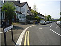
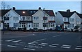
E10 5JT is a compact residential postcode in England, home to 2,147 people. This small cluster of homes sits at the heart of a community defined by its proximity to transport links and local amenities. The area’s character is shaped by its mix of retail, public transport, and nearby green spaces. Residents benefit from a well-connected location, with multiple train and metro stations within reach. The median age of 47 suggests a mature population, many of whom are likely long-term residents. Daily life here balances practicality with accessibility, offering a quiet residential environment without sacrificing convenience. While the area lacks large-scale developments, its small size fosters a sense of familiarity. The absence of major planning constraints means residents face fewer restrictions on property use or development. For those seeking a manageable, well-serviced area with a low crime rate, E10 5JT provides a stable backdrop for living.
- Area Type
- Postcode
- Area Size
- Not available
- Population
- 2147
- Population Density
- 13776 people/km²
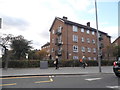
The property market in E10 5JT is characterised by a high proportion of flats, with no data suggesting the presence of larger homes or detached properties. With only 34% of residents owning their homes, the area leans heavily towards rental properties, likely catering to tenants seeking affordable housing in a connected location. This suggests a dynamic between landlords and renters, with limited scope for long-term equity growth for buyers. The small size of the postcode means the housing stock is tightly concentrated, possibly around a central hub or development. For prospective buyers, this could imply competition for a limited number of properties, though the area’s transport links and amenities may offset this. The flat-dominated market may appeal to those prioritising convenience over space, particularly commuters or those working in nearby urban centres.
House Prices in E10 5JT
No properties found in this postcode.
Energy Efficiency in E10 5JT
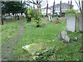
Living in E10 5JT grants access to a range of amenities within practical reach. Retail options include major supermarkets like Tesco Leyton and Sainsburys Leyton, ensuring everyday shopping needs are met. The area’s transport links connect residents to broader leisure opportunities, with ferry access to Canary Wharf and London City Airport offering both business and recreational benefits. Nearby stations like Leytonstone High Road and Stratford High Street provide access to cultural hubs, dining, and entertainment. While the data does not specify parks or green spaces, the absence of environmental constraints suggests open areas may be available nearby. The combination of retail, transport, and proximity to urban centres creates a lifestyle that balances convenience with accessibility, ideal for those prioritising connectivity over isolated living.
Amenities
Schools
| Rank | School | Type | Entry gender | Ages |
|---|
Explore more schools in this area
Go to Schools tabDemographics
The population of E10 5JT is predominantly adults aged 30–64, with a median age of 47. This suggests a community of established professionals and families, many of whom may be in their peak working years. Home ownership here is relatively low at 34%, indicating that a majority of residents rent their properties. The accommodation type is almost entirely flats, which aligns with the area’s density and likely proximity to urban infrastructure. The predominant ethnic group is White, though specific data on diversity is not provided. The age profile and ownership figures suggest a stable, mature demographic with fewer young families or students. The low deprivation levels implied by the data—such as the 34% ownership rate—may reflect a community with access to services and employment opportunities, though this is not explicitly stated.
Household Size
Accommodation Type
Tenure
Ethnic Group
Religion
Household Composition
Age
Household Deprivation
NS-SEC
Explore more demographic insights in this area
Go to Demographics tabPlanning
Planning Constraints
- Flood RiskPremium
- Ramsar Wetland SitesPremium
- Area of Outstanding Natural BeautyPremium
- Protected Nature ReservePremium
- Protected WoodlandPremium