Area Overview for Dalgarno Ward
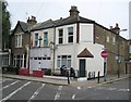
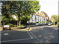
Photos of Dalgarno Ward


Area Information
Dalgarno Ward is a defined district borough unitary ward situated within England, covering a total area of 88.9 hectares. Living in Dalgarno Ward involves navigating a specific local landscape defined by clear administrative boundaries and a compact physical footprint. The area's identity is shaped by its demographic profile, which suggests a community with distinct characteristics compared to broader national averages. You will find that daily life here is influenced by a very high median age of 70 years. This statistic indicates that the population is significantly older than typical residential zones, suggesting a community where proximity to retirement facilities or quiet recreational spaces is likely prioritised. Those looking for homes in Dalgarno Ward should understand that the area is not designed for a young-family demographic in the traditional sense. Instead, it reflects a neighbourhood where established residents dominate. The physical size of 88.9 hectares provides enough space for local parks or communal areas, though the specific layout of these amenities is not detailed in the core demographic dataset. For a prospective buyer, the key takeaway is that this is a mature ward where the rhythm of life moves at a pace suited to an older population structure. The area stands as a recognised unit with fixed borders, making it straightforward to identify within official records and property listings.
- Area Type
- District Borough Unitary Ward
- Area Size
- 88.9 hectares
- Population
- Not available
- Population Density
- Not available
Demographics
The community within Dalgarno Ward is defined by a sharply aged population with a median age of 70 years. Residents living in this ward are, on average, significantly older than the national demographic, creating an environment where services catering to seniors are likely central to daily life. You will find that the age profile skews heavily towards older residents, meaning neighbourhood activities and local events are tailored to this specific age group. While the data aggregates all age ranges under a single "Age: Total" category, the median figure of 70 provides a precise indicator of the community's generational makeup. Home ownership in Dalgarno Ward sits at a relatively low 20%. This figure suggests that the majority of households likely reside on long-term tenancies rather than owning their properties outright. Such a high rental occupancy rate often points to social housing provisions or local authority accommodation common in areas with aged populations. The household composition and accommodation type data are recorded as totals, indicating a standard aggregation of resident types without further granular breakdown in the provided records. Regarding diversity, the predominant ethnic group and religious affiliations are recorded at the total level, implying a standardised categorisation across the ward. While specific percentages are not itemised for further subgroups, the overall structure of the population is clear. For those considering living in Dalgarno Ward, the social fabric is built around a homogenous age demographic. There are no indications in the data of significant youth influx or large young-family clusters. The area represents a settled, older community where social interactions and lifestyle choices reflect the needs of a 70-year-old median resident.
Household Size
Accommodation Type
Tenure
Ethnic Group
Religion
Household Composition
Age
Household Deprivation
NS-SEC
Explore more demographic insights in this area
Go to Demographics tabPlanning
Planning Constraints
- Flood RiskPremium
- Ramsar Wetland SitesPremium
- Area of Outstanding Natural BeautyPremium
- Protected Nature ReservePremium
- Protected WoodlandPremium
- Crime RiskPremium