Area Overview for DA8 3EG
Photos of DA8 3EG


Area Information
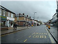
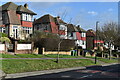
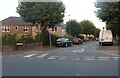
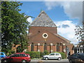
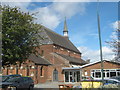
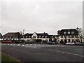
Northumberland Heath, covered by the DA8 3EG postcode, is a specific residential cluster within the London Borough of Bexley. This area sits on high ground south of Erith and north of Bexleyheath. Although the postcode covers a small physical footprint of roughly 2.8 hectares, it hosts a population of 1,424 people. The name derives from Old English, indicating land north of a stream, rather than any connection to the northern English county. Historically, this district was common ground or heath. Significant settlement began in the nineteenth century with the construction of a workhouse in 1805. Residential development intensified in the 1880s. Today, the district has transformed from barren heath into a thriving residential community. Living in DA8 3EG means residing in a suburb that escaped relatively light bombing damage during the Second World War, though a flying bomb landed on Hurst Road in 1944. The area is centred around historic junctions like Brook Street and Bedonwell Road. It remains mainly residential and suburban in character. You will find Victorian housing stock, some 1940s council developments, and a Cottage estate built specifically for Vickers armaments workers in 1916. A conservation area on Brook Street safeguards early examples of municipal housing. St Paul's Church, consecrated in 1901, stands as a notable feature alongside the large Catholic church opened in 1963. For residents, the area offers a blend of history and established village life without the bustle of larger urban centres.
- Area Type
- Postcode
- Area Size
- 2885 m²
- Population
- Not available
- Population Density
- Not available
The property market in DA8 3EG is defined by a high proportion of owner-occupied dwellings. With 62 per cent of households owning their homes, this area operates more as an investment and settlement market than a high-velocity rental sector. The predominant accommodation type is houses, which reflects the suburban expansion that began in the nineteenth century. You will find Victorian properties alongside 1940s council developments and the Cottage estate built in 1916. The high ownership rate implies stable tenants and a community where cash buyers and owners dominate. This environment typically means fewer landlords managing temporary tenancies compared to larger urban postcodes. The housing stock includes terraced homes in the conservation area on Brook Street and larger family houses on the south side of Manor Road. The area was originally developed partly by local builders like Blackwell and Meyer in the early twentieth century. This history has left a legacy of substantial housing stock. If you are looking at homes in DA8 3EG, expect a market focused on family homes rather than purpose-built flats. The presence of a workhouse from 1805 and the subsequent development into a village centre adds to the character of the properties. Most homes here are likely to be detached or semi-detached, typical of the suburban sprawl established after the Enclosure Act of 1812. Buying into this postcode often means purchasing a piece of established history rather than a speculative development.
House Prices in DA8 3EG
Showing 12 properties
| Address | Type | Beds | Baths | Last Sale Price | Last Sale Date | |
|---|---|---|---|---|---|---|
| 10 Hurst Road, Erith, DA8 3EG | house | - | - | £335,000 | Jun 2022 | |
| 24 Hurst Road, Erith, DA8 3EG | house | - | - | £375,000 | Nov 2021 | |
| 14 Hurst Road, Erith, DA8 3EG | house | - | - | £305,000 | Jun 2021 | |
| 20 Hurst Road, Erith, DA8 3EG | Terraced | 3 | - | £295,000 | Jul 2017 | |
| 4 Hurst Road, Erith, DA8 3EG | house | - | - | £229,000 | May 2014 | |
| 22 Hurst Road, Erith, DA8 3EG | Terraced | 4 | 2 | £200,000 | Jan 2012 | |
| 16 Hurst Road, Erith, DA8 3EG | Terraced | - | - | £63,950 | Aug 1997 | |
| 8 Hurst Road, Erith, DA8 3EG | Terraced | - | - | £56,500 | Mar 1997 | |
| 2 Hurst Road, Erith, DA8 3EG | Terraced | - | - | - | - | |
| 12 Hurst Road, Erith, DA8 3EG | Terraced | - | - | - | - |
Energy Efficiency in DA8 3EG
Daily life in DA8 3EG benefits from a practical network of amenities within easy reach. Residents have access to five major retail units, notably including Tesco Northumberland, Sainsburys Barnehurst, and Sainsburys Erith. These supermarkets provide comprehensive shopping needs without requiring a long drive. For rail access, you can utilise five stations, specifically Erith, Barnehurst Station, and Slade Green. Ferry options include Woolwich Arsenal Pier, Woolwich Ferry North Pier, and Barrier Gardens Pier, offering river crossings. The area also connects to DLR stations like Gallions Reach Station, Dagenham Heathway, and King George V. London City Airport is within the broader accessible range. This density of facilities means you can run errands locally while retaining access to wider city infrastructure. The industrial bakery on Belmont Road is a historic feature that adds to the local character. Northumberland Heath Baptist Church, established with its first building in 1900, serves as a community landmark. The conservation area on Brook Street preserves the historic streetscape. You can walk to certain amenities from the core of the postcode. The proximity of multiple train stations and supermarkets creates a self-sufficient lifestyle. Parent households like those in the nearby schools can manage daily schedules easily with these resources. The area feels like functioning suburbia where convenience and transport go hand in hand.
Amenities
Schools
Families in DA8 3EG have access to a mix of primary and academy schools within the local borough. St Fidelis Catholic Primary School holds an outstanding Ofsted rating, offering a top-tier educational option for younger children. Erith School appears in records as both a primary institution and an academy, potentially indicating different stages or catchment variations. King Henry School and Leigh Academy Bexley are also nearby academy options for secondary education. The presence of St Fidelis provides a Catholic schooling choice with a proven track record of success as per the latest regulations. Erith School serves as a key local institution, while the academies offer alternative educational pathways. The variety of school types means parents have choices between faith-based and state academy options. You will find that the school catchments cover the immediate neighbourhood of Northumberland Heath. The outstanding rating of St Fidelis suggests a strong focus on educational outcomes in the area. For those considering moving into DA8 3EG, the proximity of these five listed schools ensures that children have immediate access to education. The mix includes both traditional primary settings and modern academy structures. This diversity supports families who prioritise academic excellence alongside local community schooling.
| Rank | School | Type | Entry gender | Ages |
|---|
Explore more schools in this area
Go to Schools tabDemographics
The community in DA8 3EG reflects the maturity of a long-established residential suburb. The median age is 47, and adults between 30 and 64 years represent the most common age range. This demographic profile suggests an area populated by families and professionals with stable lives. Home ownership stands at 62 per cent, placing this postcode above the national average. This figure indicates that a majority of residents live in their own properties rather than renting. The predominant accommodation type consists of houses, which aligns with the suburban character described in the area's history. The predominant ethnic group is White, consistent with the historical development patterns of the district. The small population of 1,424 residents within 2885 square metres creates a high density environment of 493,648 people per square kilometre. While the density figure is high due to the small administrative boundary of the postcode, the area's physical spread and historic village centre suggest a tight-knit neighbourhood feel. You are likely to encounter a stable community where long-term residents form the core of the population. The sophistication of the housing stock, including Victorian cottages and inter-war developments, caters well to this middle-aged demographic. The lack of young children or elderly dependency ratios in the specific data suggests a balanced family orientation. Living in this postcode means being part of a mature society accustomed to the rhythms of suburban life.
Household Size
Accommodation Type
Tenure
Ethnic Group
Religion
Household Composition
Age
Household Deprivation
NS-SEC
Explore more demographic insights in this area
Go to Demographics tabPlanning
Planning Constraints
- Flood RiskPremium
- Ramsar Wetland SitesPremium
- Area of Outstanding Natural BeautyPremium
- Protected Nature ReservePremium
- Protected WoodlandPremium