Area Overview for DA8 2DW
Photos of DA8 2DW


Area Information
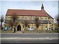
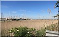
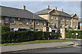
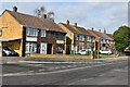
DA8 2DW is a small residential postcode area in the London Borough of Bexley, encompassing the suburbs of Slade Green and North End. With a population of 2,050 and a density of 1,355 people per square kilometre, it is a compact, tightly knit community. The area lies near the River Thames and River Darent, with historical roots tracing back to the 16th century. Its development accelerated in the Edwardian era as a railway village, with Slade Green Station opening in 1900. Today, the area balances suburban tranquillity with proximity to London’s transport networks. Residents benefit from a mix of historical sites, such as St Augustine’s Church and the former Thames Munition Works, alongside modern amenities. The postcode is part of the Slade Green & Northend electoral ward, known for its postwar housing developments. Daily life here is characterised by a low population density, suggesting a slower pace compared to denser urban areas, with a focus on local community ties and accessible transport links to nearby towns and London.
- Area Type
- Postcode
- Area Size
- Not available
- Population
- 2050
- Population Density
- 1355 people/km²
DA8 2DW is primarily an owner-occupied area, with 64% of homes owned by residents rather than rented. The accommodation type is predominantly houses, which is typical for suburban settings. This suggests a market skewed towards family homes and long-term investment rather than rental properties. The small size of the area means housing stock is limited, but the focus on houses implies a preference for spacious, private living. For buyers, this could mean a competitive market with fewer options, but properties may retain value due to their rarity in such a compact postcode. The presence of postwar housing developments and historical buildings, such as the conservation area on Oak Road, adds character and potential for unique properties. However, the small scale of the area means buyers should consider proximity to larger towns like Bexleyheath or Dartford for additional housing choices.
House Prices in DA8 2DW
No properties found in this postcode.
Energy Efficiency in DA8 2DW
Living in DA8 2DW offers access to a range of amenities within practical reach. Retail options include Budgens Slade, Morrisons Erith, and Tesco Erith, providing daily essentials and groceries. The area’s transport links connect residents to larger retail and leisure hubs in nearby towns. For dining, while specific restaurants are not listed, the proximity to Erith and Slade Green suggests a variety of local eateries. Parks and green spaces are not explicitly detailed in the data, but the historical presence of the Thames Munition Works site and nearby rivers may offer recreational opportunities. The area’s railway heritage and conservation zones, such as Oak Road’s 1900 cottages, contribute to a distinct character. Overall, the combination of shops, transport, and historical sites creates a convenient, community-focused lifestyle with easy access to London’s broader amenities.
Amenities
Schools
| Rank | School | Type | Entry gender | Ages |
|---|
Explore more schools in this area
Go to Schools tabDemographics
The population of DA8 2DW has a median age of 47, with the majority of residents aged between 30 and 64. This suggests a mature, stable community, likely with established families and professionals. Home ownership is high at 64%, indicating a strong presence of long-term residents. The area is predominantly occupied by houses, reflecting a suburban character rather than high-density living. The predominant ethnic group is White, which aligns with broader trends in the London Borough of Bexley. The population density of 1,355 people per square kilometre implies a mix of single-family homes and small clusters of properties, fostering a sense of privacy and space. This demographic profile suggests a community focused on stability, with fewer transient populations. The age range and ownership figures indicate a place where residents are likely to have long-term plans, such as raising children or retirement, rather than short-term tenancies.
Household Size
Accommodation Type
Tenure
Ethnic Group
Religion
Household Composition
Age
Household Deprivation
NS-SEC
Explore more demographic insights in this area
Go to Demographics tabPlanning
Planning Constraints
- Flood RiskPremium
- Ramsar Wetland SitesPremium
- Area of Outstanding Natural BeautyPremium
- Protected Nature ReservePremium
- Protected WoodlandPremium