Area Overview for DA7 6TA
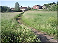
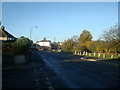
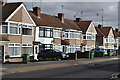
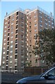
Photos of DA7 6TA


Area Information
Living in DA7 6TA means inhabiting a small, tightly knit residential cluster in the London Borough of Bexley. With a population of 1620, the area balances quiet suburban life with proximity to London’s transport networks. Historically rooted in the May Place estate, which became the Barnehurst Estate in the 1920s, the area features semi-detached homes built during a period of early 20th-century expansion. The median age of 47 suggests a mature, stable community, with most residents falling within the 30-64 age range. Daily life is shaped by its transport links: Barnehurst railway station, opened in 1895, connects to the Bexleyheath Line, while nearby metro and rail stations offer access to central London. The area’s charm lies in its blend of historical architecture and modern convenience, with amenities like the Barnehurst Golf Course and proximity to London City Airport adding to its appeal. It’s a place where homeownership is prevalent, and the character of the neighbourhood reflects its long-standing residential traditions.
- Area Type
- Postcode
- Area Size
- Not available
- Population
- 1620
- Population Density
- 6998 people/km²
DA7 6TA is a predominantly owner-occupied area, with 84% of residents owning their homes. The housing stock consists almost entirely of houses, many of which date back to the early 20th century. The Barnehurst Estate, developed in the 1920s by J.W. Ellingham, remains a defining feature of the area, with semi-detached homes built along Barnehurst Road. These properties, originally sold for £600, have likely appreciated significantly over time. The limited size of the postcode area means the housing market is compact, with properties concentrated in a small cluster. For buyers, this suggests a niche market with limited new developments but strong potential for capital growth. The high home ownership rate indicates a stable demand for existing properties, though the small scale of the area may limit availability for those seeking rental options.
House Prices in DA7 6TA
No properties found in this postcode.
Energy Efficiency in DA7 6TA
DA7 6TA offers a mix of practical amenities and historical landmarks within easy reach. Retail options include Tesco Erith, Morrisons Daily, and Budgens Slade, providing everyday shopping needs. The Barnehurst Golf Course, established in 1903, remains a notable local attraction, though the historic May Place mansion—once its clubhouse—was destroyed by fire in 1959. Nearby, Hall Place in Bexley, dating to 1537, offers a glimpse into the region’s heritage. The area’s transport links ensure access to larger urban centres, while the presence of multiple rail and metro stations supports a commuter-friendly lifestyle. The blend of retail, leisure, and historical sites contributes to a balanced daily life, combining suburban tranquillity with urban accessibility.
Amenities
Schools
| Rank | School | Type | Entry gender | Ages |
|---|
Explore more schools in this area
Go to Schools tabDemographics
DA7 6TA’s population of 1620 is predominantly composed of adults aged 30-64, with a median age of 47. This suggests a community of established professionals and families, many of whom are likely long-term residents. Home ownership is exceptionally high at 84%, indicating a stable, owner-occupied demographic. The area is characterised by houses rather than flats, reflecting a preference for standalone or semi-detached properties. The predominant ethnic group is White, though specific diversity metrics are not provided. The high home ownership rate and mature age profile suggest a low turnover of residents, fostering a sense of continuity. The absence of detailed deprivation data means the area’s quality of life is inferred from its infrastructure and safety assessments, which are largely positive. This demographic profile aligns with a community prioritising stability and long-term residency over transient living.
Household Size
Accommodation Type
Tenure
Ethnic Group
Religion
Household Composition
Age
Household Deprivation
NS-SEC
Explore more demographic insights in this area
Go to Demographics tabPlanning
Planning Constraints
- Flood RiskPremium
- Ramsar Wetland SitesPremium
- Area of Outstanding Natural BeautyPremium
- Protected Nature ReservePremium
- Protected WoodlandPremium