Area Overview for DA7 4QS
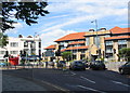
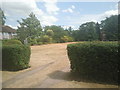
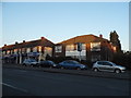
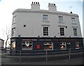
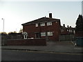
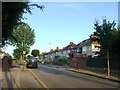
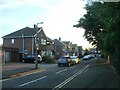
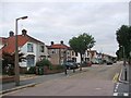
Photos of DA7 4QS


Area Information
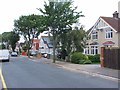
DA7 4QS is a small residential cluster in the London Borough of Bexley, situated within the historically significant town of Bexleyheath. This area, covering 4,169 m², is home to 1,656 residents, making it one of the most densely populated zones in England, with 397,247 people per square kilometre. The postcode area reflects Bexleyheath’s evolution from a 19th-century heathland into a suburban hub, shaped by the 1814 Enclosure Acts that enabled private housing development. Today, it retains a quiet, residential character with a focus on family living. Its proximity to Bexley’s administrative centre and historic Watling Street road links it to both local and broader London networks. Residents benefit from a mix of suburban tranquillity and access to nearby amenities, including schools, transport hubs, and retail centres. The area’s compact size means it is ideal for those seeking a close-knit community with easy access to urban opportunities.
- Area Type
- Postcode
- Area Size
- 4169 m²
- Population
- 1656
- Population Density
- 6492 people/km²
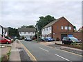
The property market in DA7 4QS is characterised by a high rate of home ownership (65%) and a predominance of houses, indicating a market skewed towards owner-occupied, family homes. This suggests a stable, low-turnover environment where properties are likely to retain value over time. Given the area’s small size and limited housing stock, the market is likely to be competitive for buyers seeking homes in the immediate vicinity. The concentration of houses rather than flats or apartments may appeal to those prioritising space and private outdoor areas. However, the compact nature of the postcode means that buyers should consider nearby areas for more options. The high home ownership rate also implies a community with long-term residents, which can contribute to a sense of continuity and local identity.
House Prices in DA7 4QS
Showing 2 properties
| Address | Type | Beds | Baths | Last Sale Price | Last Sale Date | |
|---|---|---|---|---|---|---|
| 21-35 Mayplace Road West, Bexleyheath, DA7 4QS | undefined | - | - | - | - | |
| 41-45 Mayplace Road West, Bexleyheath, DA7 4QS | Semi-detached | 3 | 1 | - | - |
Energy Efficiency in DA7 4QS
DA7 4QS offers a range of amenities within practical reach, enhancing daily life for residents. Nearby retail options include Sainsburys Bexleyheath, M&S Bexleyheath, and Lidl Bexleyheath, providing access to groceries, clothing, and household essentials. The area’s rail and metro stations, such as Bexleyheath and Gallions Reach, connect to London’s transport network, facilitating easy travel to work, shopping, or leisure activities. Ferry services at Woolwich Arsenal Pier and Woolwich Ferry North Pier add convenience for those needing river crossings. The proximity to London City Airport makes the area suitable for those requiring frequent air travel. While the area itself is residential, its location near Bexley’s administrative centre ensures access to broader urban amenities. The mix of retail, transport, and connectivity options supports a balanced lifestyle, blending suburban comfort with urban accessibility.
Amenities
Schools
Residents of DA7 4QS have access to two primary schools: Pelham Primary School and Pelham Infant School. Both institutions cater to younger children, providing a local option for families with school-age children. The presence of two primary schools in close proximity suggests a well-supported educational infrastructure for the area’s younger population. However, the data does not include Ofsted ratings or specific academic performance metrics, so prospective families should conduct further research to assess the quality of education. The availability of two primary schools reduces the need for long commutes, which is a practical advantage for parents. For secondary education, residents may need to look beyond the immediate area, but the proximity to Bexley’s administrative centre likely offers broader options.
| Rank | School | Type | Entry gender | Ages |
|---|
Explore more schools in this area
Go to Schools tabDemographics
DA7 4QS has a median age of 47, with the majority of residents aged between 30 and 64. This suggests a mature, stable population, likely composed of long-term residents and families. Home ownership is high at 65%, indicating a strong preference for owning property rather than renting. The area is predominantly composed of houses, which aligns with the demographic profile of older, established households. The predominant ethnic group is White, reflecting the broader demographic trends of the London Borough of Bexley. While no specific deprivation data is provided, the high home ownership and age range suggest a community with relatively stable economic conditions. However, the lack of diversity in ethnic composition may limit cultural vibrancy compared to more cosmopolitan areas.
Household Size
Accommodation Type
Tenure
Ethnic Group
Religion
Household Composition
Age
Household Deprivation
NS-SEC
Explore more demographic insights in this area
Go to Demographics tabPlanning
Planning Constraints
- Flood RiskPremium
- Ramsar Wetland SitesPremium
- Area of Outstanding Natural BeautyPremium
- Protected Nature ReservePremium
- Protected WoodlandPremium