Area Overview for DA6 8UA
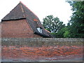
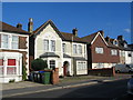
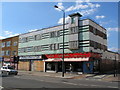
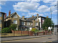
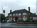
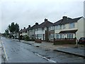
Photos of DA6 8UA


Area Information
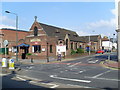
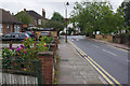
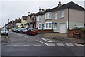
DA6 8UA is a small residential cluster in the London Borough of Bexley, situated along Watling Street (A207) near the western edge of Bexleyheath. With a population of 1,591, it forms part of Crook Log Ward, a locality that merges seamlessly with Bexleyheath and Welling. The area’s name originates from the historic Crook Log public house, first referenced in 1738 and later mentioned by Charles Dickens. Its compact size and proximity to major routes like the A207 make it a convenient base for commuters. Daily life here is shaped by its integration with nearby towns, offering a balance of suburban tranquillity and access to London’s infrastructure. The area’s demographics reflect a mature community, with a median age of 47 and a strong presence of adults aged 30–64. This suggests a stable, established population, many of whom are likely long-term residents. The predominance of houses over flats, combined with a 79% home ownership rate, indicates a community focused on private living rather than rental properties.
- Area Type
- Postcode
- Area Size
- Not available
- Population
- 1591
- Population Density
- 5577 people/km²
DA6 8UA is primarily an owner-occupied area, with 79% of homes owned by residents rather than rented. The housing stock is dominated by houses, which are more common than flats in this small postcode. This suggests a community focused on family-oriented living, with properties likely offering more space and privacy than typical urban dwellings. The high home ownership rate indicates a stable market, though the area’s small size means the available housing stock is limited. Buyers should consider nearby areas like Bexleyheath and Welling, which may offer more options. The predominance of houses also implies that properties here are likely to be larger, with gardens or outdoor spaces, catering to those seeking suburban comfort. However, the compact nature of DA6 8UA means that the immediate surroundings, rather than the postcode itself, may hold the most significant property diversity.
House Prices in DA6 8UA
No properties found in this postcode.
Energy Efficiency in DA6 8UA
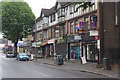
Living in DA6 8UA offers access to a range of amenities within practical reach. Retail options include Asda Bexleyheath, Sainsburys Avenue, and other local shops, ensuring daily needs are met. The area’s rail stations, such as Bexleyheath and Barnehurst, provide connections to London and surrounding towns, while ferry piers like Woolwich Arsenal Pier offer transport across the Thames. Metro stations like King George V. and Gallions Reach add to the area’s accessibility. The proximity to London City Airport makes travel convenient for those requiring air transport. Though the area itself is small, its integration with Bexleyheath and Welling expands leisure and dining options. The presence of multiple transport hubs and retail spots suggests a lifestyle that balances convenience with suburban calm, ideal for those seeking ease of movement without urban congestion.
Amenities
Schools
| Rank | School | Type | Entry gender | Ages |
|---|
Explore more schools in this area
Go to Schools tabDemographics
DA6 8UA’s population of 1,591 is predominantly composed of adults aged 30–64, with a median age of 47. This suggests a mature, settled community, likely with a strong presence of families and professionals in their middle years. Home ownership is high at 79%, indicating a stable housing market and a focus on long-term residency. The area is characterised by houses rather than flats, reflecting a preference for single-family homes. The predominant ethnic group is White, though specific data on diversity is not provided. The absence of detailed information on deprivation or income levels means the area’s quality of life can only be inferred from its infrastructure and amenities. The low crime score of 78/100, combined with no flood or environmental risks, suggests a safe, low-stress environment. This demographic profile paints a picture of a community that values stability, private property, and proximity to essential services.
Household Size
Accommodation Type
Tenure
Ethnic Group
Religion
Household Composition
Age
Household Deprivation
NS-SEC
Explore more demographic insights in this area
Go to Demographics tabPlanning
Planning Constraints
- Flood RiskPremium
- Ramsar Wetland SitesPremium
- Area of Outstanding Natural BeautyPremium
- Protected Nature ReservePremium
- Protected WoodlandPremium