Area Overview for DA6 7LB
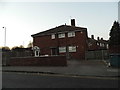
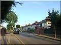
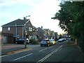
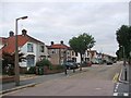
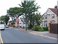
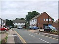
Photos of DA6 7LB


Area Information
DA6 7LB is a compact residential postcode in the London Borough of Bexley, nestled in the suburban town of Bexleyheath. With a population of 1,864 spread over 2,367 square metres, this area is densely populated yet retains a historical character rooted in 19th-century enclosure acts that transformed scrubland into private housing. The ward, centred around DA6 7AB, lies along the historic Watling Street, a Roman road that once linked London to Dover. Daily life here is shaped by its proximity to transport hubs, including Bexleyheath Station and London City Airport, which sit within practical reach. The area’s mix of older homes and modern infrastructure reflects its evolution from a rural heath to a suburban community. Residents benefit from a network of retail outlets, including Lidl and Sainsbury’s, and a rail system that connects to central London. While the population density is high, the area’s small size means amenities are closely clustered, offering convenience for those prioritising accessibility over sprawling open spaces.
- Area Type
- Postcode
- Area Size
- 2367 m²
- Population
- Not available
- Population Density
- Not available
DA6 7LB is a largely owner-occupied area, with 81% of homes owned by residents rather than rented. The accommodation type is predominantly houses, which is unusual for urban areas and suggests a focus on family-friendly living. This housing stock indicates a market where property is typically held long-term, with limited turnover. However, the small area size means the housing stock is finite, and buyers must consider proximity to nearby amenities rather than expansive surroundings. The high home ownership rate also implies a stable market, but the lack of rental properties may limit options for those seeking short-term or flexible housing. For buyers, the area’s compact nature means properties are likely to be in close proximity to transport links, schools, and retail, though the limited size could restrict choices for larger families or those prioritising space.
House Prices in DA6 7LB
No properties found in this postcode.
Energy Efficiency in DA6 7LB
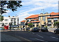
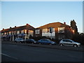
Living in DA6 7LB offers access to a range of amenities within practical reach. Retail options include Lidl Bexleyheath, Sainsbury’s Bexleyheath, and M&S Bexleyheath, providing everyday shopping convenience. The area’s transport links, such as Bexleyheath Station and Woolwich Ferry North Pier, connect residents to broader London networks. Historically, the ward is centred on the Broadway, a commercial spine with landmarks like Christ Church (consecrated 1877) and the Red House (designed by Philip Webb for William Morris). Parks and open spaces are limited, but nearby Danson Park offers greenery. The mix of retail, transport, and heritage sites creates a characterful environment, blending suburban convenience with historical depth. For families, the proximity to schools and the compact layout of the area enhance daily life, though the high population density may impact personal space.
Amenities
Schools
| Rank | School | Type | Entry gender | Ages |
|---|
Explore more schools in this area
Go to Schools tabDemographics
The community in DA6 7LB is predominantly middle-aged, with a median age of 47 and the most common age range being adults aged 30–64. This suggests a stable population with strong family ties, reflected in the high home ownership rate of 81%. The area is primarily composed of houses, indicating a preference for single-family living over flats or apartments. The predominant ethnic group is White, which aligns with broader trends in the borough. While specific data on deprivation is absent, the high home ownership rate and age profile imply a community with established roots and long-term residency. The absence of detailed diversity statistics means the demographic profile remains focused on its core demographic, with no indication of significant ethnic or socioeconomic variation.
Household Size
Accommodation Type
Tenure
Ethnic Group
Religion
Household Composition
Age
Household Deprivation
NS-SEC
Explore more demographic insights in this area
Go to Demographics tabPlanning
Planning Constraints
- Flood RiskPremium
- Ramsar Wetland SitesPremium
- Area of Outstanding Natural BeautyPremium
- Protected Nature ReservePremium
- Protected WoodlandPremium