Area Overview for DA15 7AB
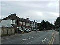
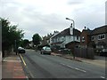
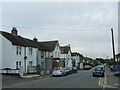
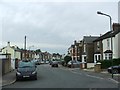
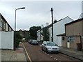
Photos of DA15 7AB


Area Information
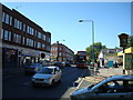
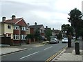
Living in DA15 7AB means residing in a specific postcode area covering a small residential cluster within the Blackfen & Lamorbey Ward of the London Borough of Bexley. This locale encompasses approximately 1.0 hectares and holds a population of 2054 residents. The demography reflects a mature community with a median age of 47, where the majority of the population consists of adults aged between 30 and 64 years. Historically, the land was farmland until the interwar period, when the sale of the Danson Estate in 1922 prompted rapid house-building. Developers like Ideal Homesteads and Leech Estates constructed much of the street network by 1937, creating a suburban environment dominated by 1930s owner-occupied houses. Today, you find yourself in an area that mixes this conventional British design with pockets of later development, such as the flats built at Merino Place in 1957. The location lies north of Sidcup and south of Welling, bordering the Royal Borough of Greenwich. While the name Blackfen refers to dark, marshy soil, the current environment is primarily built-up housing. You can expect a quiet, established neighbourhood where the past of Danson and Lamorbey estates meets modern daily life.
- Area Type
- Postcode
- Area Size
- 1.0 hectares
- Population
- 2054
- Population Density
- 4436 people/km²
The property market in DA15 7AB reflects a distinct character shaped by its limited size and specific housing stock. Although the immediate postcode covers an area of just 1.0 hectare, the wider Blackfen & Lamorbey Ward tells the story of the 1930s owner-occupied housing boom. Globally, the discovery of the Blackfen area's history might be fascinating, but locally, the defining feature is the mix of property types. Flats are a key accommodation type listed for this area, distinguishing it from exclusively suburban streets of semi-detached houses. The 56% home ownership rate indicates that sales transactions occur frequently, yet the market remains stabilised by a significant rental sector. Buyers looking at homes in DA15 7AB should note that the accommodation type varies between the historical Danson Estate houses and modern conversions or post-war rises. The area is not a large sprawling suburb; it is a small residential cluster where property values are influenced heavily by proximity to Sidcup and Welling. If you are considering purchasing flats, you are entering a market where these units serve as a primary accommodation type. Conversely, investors or owners looking for traditional homes must navigate the streets formed by Ideal Homesteads and Leech Estates. This mix creates a diverse inventory that appeals to families and professionals alike, without the uniformity of new-build estates.
House Prices in DA15 7AB
Showing 77 properties
| Address | Type | Beds | Baths | Last Sale Price | Last Sale Date | |
|---|---|---|---|---|---|---|
| 134A Station Road, Sidcup, DA15 7AB | Flat | - | - | £60,000 | May 1998 | |
| 48, Insignis Point, 124A Station Road, Sidcup, DA15 7AB | Flat | 1 | 1 | - | - | |
| 26, Insignis Point, 124A Station Road, Sidcup, DA15 7AB | Flat | 1 | 1 | - | - | |
| 33, Insignis Point, 124A Station Road, Sidcup, DA15 7AB | Flat | 2 | 1 | - | - | |
| 34, Insignis Point, 124A Station Road, Sidcup, DA15 7AB | Flat | 2 | 1 | - | - | |
| 148A Station Road, Sidcup, DA15 7AB | Flat | 6 | 1 | - | - | |
| 51, Insignis Point, 124A Station Road, Sidcup, DA15 7AB | Flat | 1 | 1 | - | - | |
| 32, Insignis Point, 124A Station Road, Sidcup, DA15 7AB | Flat | 1 | 1 | - | - | |
| 128B Station Road, Sidcup, DA15 7AB | shop | - | - | - | - | |
| G.j. Wisdom & Co, 126 Station Road, Sidcup, DA15 7AB | retail_financial | - | - | - | - |
Energy Efficiency in DA15 7AB
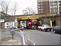
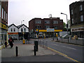
Residents of DA15 7AB benefit from a range of amenities within practical reach, blending local convenience with wider transport options. For shopping needs, five retail venues are available nearby, including M&S Sidcup, Tesco Sidcup, and Waitrose Little. These stores provide essential goods and groceries without requiring a long drive. Three railway stations serve the area, with Sidcup Station, Albany Park Station, and New Eltham offering direct rail access. Five ferry crossings are also accessible, including Woolwich Arsenal Pier, Woolwich Ferry North Pier, and Barrier Gardens Pier, providing alternative routes across the Thames. Additionally, five metro stations supply further connectivity, such as King George V., London City Airport, and Gallions Reach Station. A single airport, London City Airport, sits close enough for frequent business or leisure travel. This dense network of transport hubs means you can reach destinations quickly by train, bus, or ferry. The presence of specific retailers like Waitrose Little enhances the quality of local shopping experiences. Living in this connected environment saves time on commutes and expands your choice of leisure and work locations.
Amenities
Schools
Families considering living in DA15 7AB have access to a range of educational institutions within the nearby Blackfen & Lamorbey Ward. Four to five major schools serve the local population, offering options for both infants and academically focused education. Birkbeck Primary School holds a Good Ofsted rating, providing certified quality for younger children. Holy Trinity Lamorbey Church of England Primary School also serves the local community as a primary institution. For older students, Chislehurst and Sidcup Grammar School stands out as both a primary and an academy with a Good Ofsted rating. Additionally, Holy Trinity Lamorbey Church of England School operates as an academy with a Good Ofsted rating, ensuring consistent standards across the sector. This concentration of highly-rated schools means you do not need to travel far to find quality education for your children. The presence of multiple academies alongside church schools offers families a choice between different educational philosophies while maintaining high standards. Residing in this area puts your children in close proximity to these key learning hubs, reducing the need for long commutes to school each day.
| Rank | School | Type | Entry gender | Ages |
|---|
Explore more schools in this area
Go to Schools tabDemographics
The community in DA15 7AB is defined by its demographic profile, which shows a median age of 47 years. Adults aged between 30 and 64 years form the most common age range, indicating a stable, older presence rather than a youthful student population. Home ownership stands at 56%, suggesting that more than half of the residents own their dwellings outright or with a mortgage, while nearly half rent. The predominant accommodation type in this small postcode area consists of flats, which contrasts with the 1930s houses found nearby in the wider ward. This mix implies a building fabric that includes both standalone family homes and apartment blocks suitable for smaller households. Predominantly White residents make up the main ethnic group, reflecting the area's historical development patterns. With a population density of 204,375 people per square kilometre, the area is relatively compact. You will find a settled community where long-term residents outnumber transient groups. The high level of home ownership often translates to a quieter street life compared to purely rented areas, though the prevalence of flats introduces a different dynamic to the streetscape.
Household Size
Accommodation Type
Tenure
Ethnic Group
Religion
Household Composition
Age
Household Deprivation
NS-SEC
Explore more demographic insights in this area
Go to Demographics tabPlanning
Planning Constraints
- Flood RiskPremium
- Ramsar Wetland SitesPremium
- Area of Outstanding Natural BeautyPremium
- Protected Nature ReservePremium
- Protected WoodlandPremium