Area Overview for DA14 6DU
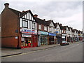
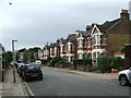
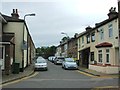
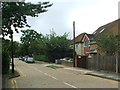
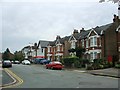
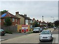
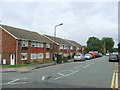
Photos of DA14 6DU


Area Information
DA14 6DU lies within the Sidcup Ward of the London Borough of Bexley, a suburban district shaped by 1930s interwar development on former rural land. With a population of 2,175, it is a small residential cluster characterised by flats and a middle-class commuter ethos. The area’s history stretches back to the 13th century, with roots in an Anglo-Saxon hamlet and growth spurred by the 1866 railway line. Today, it balances historical landmarks like St John’s Church (1901) and The Hollies conservation area with modern amenities. Residents benefit from proximity to London City Airport, rail links to Charing Cross, and nearby independent schools. The community, predominantly White and aged 30–64, reflects a stable, family-oriented demographic. Daily life is shaped by suburban convenience, with retail options like Morrisons and Waitrose within reach, and transport networks ensuring easy access to London’s core. The area’s low flood risk and absence of environmental constraints make it a practical choice for those seeking a blend of heritage and modernity without urban density.
- Area Type
- Postcode
- Area Size
- Not available
- Population
- 2175
- Population Density
- 7306 people/km²
The property market in DA14 6DU is dominated by flats, with 55% of homes owner-occupied. This suggests a mix of long-term residents and investors, though the small area size and flat-centric stock may limit housing diversity. The prevalence of flats, often found in 1930s estates like Penhill Park and Albany Park, indicates a focus on compact, functional living spaces. For buyers, this means limited scope for larger properties or bespoke renovations, but proximity to transport and amenities could offset this. The area’s modest size means the immediate surroundings—such as nearby Bexley—may offer more varied options. First-time buyers or those seeking rental properties may find opportunities here, but the market’s character is defined by its suburban, low-rise housing stock rather than high-end or luxury developments.
House Prices in DA14 6DU
No properties found in this postcode.
Energy Efficiency in DA14 6DU
Daily life in DA14 6DU is supported by a range of amenities within practical reach. Retail options include Morrisons Sidcup, Waitrose Little, and Tesco Sidcup, offering convenience for grocery shopping. The area’s rail stations—Sidcup, Albany Park, and New Eltham—provide easy access to London’s transport network, while ferry piers like Woolwich Arsenal Pier connect to the Thames. For leisure, the proximity to London City Airport and nearby parks such as Footscray Meadows offer both functional and recreational spaces. The suburban character, with its 1930s housing estates and historic buildings, creates a blend of practicality and charm. Residents benefit from a mix of local shops, transport links, and green spaces, making it suitable for those who value accessibility without the density of central London.
Amenities
Schools
The nearest school to DA14 6DU is West Lodge School, an independent institution. While no Ofsted rating is provided, the presence of an independent school suggests a focus on private education for families in the area. The lack of state schools listed means parents seeking public education may need to look beyond the immediate vicinity. However, the area’s proximity to Sidcup’s historical landmarks and transport links could make it appealing to those prioritising private schooling. The single school type listed reflects the area’s smaller scale, but its status as an independent school may cater to specific educational preferences, such as smaller class sizes or specialist curricula.
| Rank | School | Type | Entry gender | Ages |
|---|
Explore more schools in this area
Go to Schools tabDemographics
DA14 6DU has a median age of 47, with the majority of residents aged 30–64. This suggests a mature, settled community, likely centred around middle-aged professionals and families. Home ownership stands at 55%, with flats being the predominant accommodation type. This indicates a mix of owner-occupied and rental properties, though the data does not specify the proportion of renters. The predominant ethnic group is White, reflecting the area’s historical development as a traditional London suburb. The absence of specific deprivation data means no direct commentary on socioeconomic challenges, but the age profile and home ownership rate suggest a relatively stable, middle-class environment. The demographic mix implies a community focused on long-term residency, with amenities and services tailored to adult needs, such as commuter infrastructure and nearby independent schools.
Household Size
Accommodation Type
Tenure
Ethnic Group
Religion
Household Composition
Age
Household Deprivation
NS-SEC
Explore more demographic insights in this area
Go to Demographics tabPlanning
Planning Constraints
- Flood RiskPremium
- Ramsar Wetland SitesPremium
- Area of Outstanding Natural BeautyPremium
- Protected Nature ReservePremium
- Protected WoodlandPremium