Area Overview for DA14 6BP
Photos of DA14 6BP


Area Information
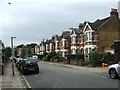
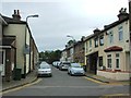
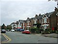
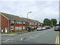
DA14 6BP is a small residential postcode cluster in the London Borough of Bexley, part of the historic Sidcup Ward. With a population of just 1,902, it reflects the character of a 1930s suburban district, built on former rural land. The area is defined by interwar housing estates like Penhill Park and Albany Park, developed by New Ideal Homesteads. Residents here enjoy a commuter-friendly environment, with easy access to rail links to London Charing Cross and nearby towns. The community is predominantly middle-class, with a median age of 47 and a strong presence of adults aged 30–64. Daily life is shaped by suburban practicality, with nearby amenities including retail outlets, schools, and transport hubs. The area’s compact size means it’s ideal for those seeking a quiet, established residential setting without the density of central London. Its proximity to Sidcup Station and London City Airport adds to its appeal for commuters and those needing frequent travel. The postcode’s small footprint and historical roots make it a distinctive choice for buyers seeking a settled, low-maintenance lifestyle.
- Area Type
- Postcode
- Area Size
- Not available
- Population
- 1902
- Population Density
- 2130 people/km²
DA14 6BP’s property market is characterised by a 41% home ownership rate, with flats being the primary accommodation type. This suggests a rental-heavy market, typical of post-war housing estates where flats dominate. The area’s small size means the housing stock is limited, with properties concentrated in 1930s developments like Penhill Park and Albany Park. Buyers should consider that the market may not offer a wide range of options, and properties are likely to be older, requiring modernisation. The flat-centric nature of the area could appeal to first-time buyers or those seeking lower maintenance. However, the limited supply may mean competition for available homes. Prospective buyers should also note that the area’s compact footprint means surrounding neighbourhoods may offer more variety, though they may lack the same historical charm.
House Prices in DA14 6BP
No properties found in this postcode.
Energy Efficiency in DA14 6BP
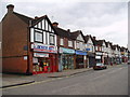
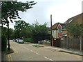
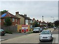
DA14 6BP offers a range of amenities within practical reach. Retail options include Morrisons Sidcup, M&S Perry Street BP, and Waitrose Little, providing everyday shopping convenience. The area’s rail network, with stations like Sidcup and Albany Park, connects residents to London and surrounding areas. Ferry services from Woolwich Arsenal Pier and Barrier Gardens Pier add to the transport diversity. Nearby is London City Airport, ideal for those needing frequent travel. The area’s suburban character is complemented by its proximity to parks and green spaces, such as Footscray Meadows. This mix of retail, transport, and leisure options supports a balanced lifestyle, with the convenience of local services reducing the need for long commutes.
Amenities
Schools
The area is served by two schools: St Mary and St Joseph’s Catholic School, a primary school, and St Luke’s Catholic Sixth Form College, also listed as a primary in the data. This mix of primary education options provides families with a range of choices, though the absence of secondary schools nearby may require commuting. The presence of both schools suggests a focus on Catholic education, which could be a consideration for families with specific preferences. The proximity of these institutions to DA14 6BP makes it a viable option for parents seeking a school-centric lifestyle. However, the lack of detailed Ofsted ratings means potential buyers should verify current performance independently.
| Rank | School | Type | Entry gender | Ages |
|---|
Explore more schools in this area
Go to Schools tabDemographics
DA14 6BP has a median age of 47, with the majority of residents aged 30–64. This suggests a mature, stable community, likely with a strong presence of families and professionals. Home ownership rates stand at 41%, indicating a mix of owner-occupied properties and rental stock. The predominant accommodation type is flats, reflecting the area’s interwar development and compact housing design. The predominant ethnic group is White, though specific diversity data is not provided. The age profile and ownership figures suggest a community that is neither young nor highly transient, with a focus on long-term residency. The 41% home ownership rate implies a significant portion of the population may be renting, which could influence local property dynamics. The absence of detailed deprivation data means the quality of life here is best inferred from the area’s amenities and safety profile.
Household Size
Accommodation Type
Tenure
Ethnic Group
Religion
Household Composition
Age
Household Deprivation
NS-SEC
Explore more demographic insights in this area
Go to Demographics tabPlanning
Planning Constraints
- Flood RiskPremium
- Ramsar Wetland SitesPremium
- Area of Outstanding Natural BeautyPremium
- Protected Nature ReservePremium
- Protected WoodlandPremium