Area Overview for CR9 8BZ
Photos of CR9 8BZ

Area Information
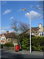
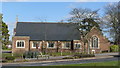
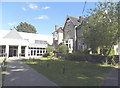
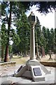
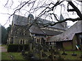
CR9 8BZ lies within the London Borough of Croydon, a historic area with roots tracing back to the 19th century. This small postcode area, part of Shirley North Ward, is a quiet residential cluster with a population of 1,612. The area’s character is shaped by its Victorian heritage, including St John the Evangelist Church, a prominent landmark designed by Sir Gilbert Scott. Shirley North Ward was established in 1955, carved from parts of Addington and East wards, reflecting Croydon’s administrative evolution. Daily life here balances suburban tranquillity with proximity to transport links. Residents benefit from nearby tram stops, rail stations, and retail hubs, while the area’s low crime risk and flood safety make it appealing. With a median age of 47 and a strong homeownership rate, CR9 8BZ is a stable, family-oriented community. Its compact size means amenities are within walking distance, and its historical ties to Croydon’s growth add a layer of continuity to modern living.
- Area Type
- Postcode
- Area Size
- Not available
- Population
- 1612
- Population Density
- 4284 people/km²
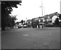
CR9 8BZ is predominantly an owner-occupied area, with 81% of homes owned by residents rather than rented. The accommodation type is largely houses, which is typical of suburban Croydon. This suggests a market skewed towards family homes and long-term residency rather than short-term rental properties. The small postcode area’s limited size means housing stock is concentrated, with fewer new developments. For buyers, this implies a stable market with established properties, though competition may be higher due to the area’s appeal. The predominance of houses also means buyers should consider larger plots and potential for garden space, which are less common in urban centres. The area’s proximity to transport links and amenities may make it attractive to those seeking a balance between suburban living and city access.
House Prices in CR9 8BZ
No properties found in this postcode.
Energy Efficiency in CR9 8BZ
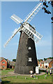
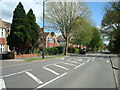
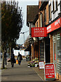
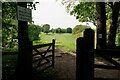
Living in CR9 8BZ offers a mix of practical amenities and suburban convenience. Nearby retail options include Co-op Shirley, M&S Shirley BP, and Tesco Shirley W, ensuring daily shopping needs are met. The area is served by five tram stops, including Blackhorse Lane, and three rail stations, facilitating easy access to London’s transport network. Proximity to Biggin Hill Airport adds to the area’s appeal for those requiring air travel. While parks and leisure facilities are not explicitly detailed in the data, the historical presence of Shirley Windmill and St John the Evangelist Church suggests a blend of heritage and community spaces. The compact nature of the postcode means amenities are within walking or cycling distance, enhancing the area’s livability.
Amenities
Schools
| Rank | School | Type | Entry gender | Ages |
|---|
Explore more schools in this area
Go to Schools tabDemographics
The population of CR9 8BZ has a median age of 47, with the majority of residents aged between 30 and 64. This suggests a mature, established community with a focus on stability. Homeownership is high, at 81%, indicating a strong presence of long-term residents. The area is predominantly composed of houses, reflecting a suburban rather than high-density housing profile. The predominant ethnic group is White, though specific diversity metrics are not detailed in the data. The age profile suggests a mix of working-age adults and retirees, with fewer young families compared to other urban areas. The low deprivation levels, inferred from the high homeownership and safety scores, imply a relatively high quality of life. This demographic profile aligns with a community prioritising security, established infrastructure, and proximity to services.
Household Size
Accommodation Type
Tenure
Ethnic Group
Religion
Household Composition
Age
Household Deprivation
NS-SEC
Explore more demographic insights in this area
Go to Demographics tabPlanning
Planning Constraints
- Flood RiskPremium
- Ramsar Wetland SitesPremium
- Area of Outstanding Natural BeautyPremium
- Protected Nature ReservePremium
- Protected WoodlandPremium