Area Overview for CR9 6BL
Photos of CR9 6BL


Area Information
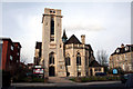
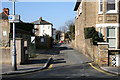
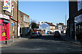
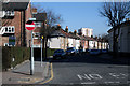
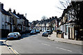
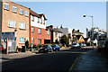
CR9 6BL is a small residential postcode in the London Borough of Croydon, nestled to the east of the town centre. It forms part of the Addiscombe West Ward, which was established in 2018 by merging parts of the former Addiscombe and Fairfield Wards. The area is defined by its quiet residential streets, with a population of 1,758 residents. Historically, Addiscombe was shaped by its connection to the East India Company, with Victorian architecture preserved in the East India Estate Conservation Area. This includes streets named after historical figures and Grade II listed buildings like Heron’s Croft. While the retail heart of Addiscombe lies in the neighbouring Addiscombe East Ward, CR9 6BL offers a more residential feel, with access to Croydon’s broader amenities. The area’s compact size and proximity to transport links make it appealing for those seeking a balance between suburban calm and urban connectivity. Its mix of historic and modern elements reflects a community rooted in the past but oriented toward contemporary living.
- Area Type
- Postcode
- Area Size
- Not available
- Population
- Not available
- Population Density
- Not available
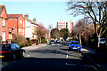
CR9 6BL is a small area with limited housing stock, characterised by a 46% home ownership rate. This indicates that the majority of properties are rented, making it a mixed market with opportunities for both buyers and renters. The accommodation type is predominantly houses, which is uncommon in many urban areas and suggests a more suburban or semi-rural character. This could appeal to buyers seeking larger living spaces or families prioritising privacy. However, the small size of the area means the housing options are limited, and buyers may need to consider nearby wards for a broader selection. The presence of houses rather than flats or apartments implies lower density and potentially more garden space. For those considering the area, the property market is likely to be competitive, with prices influenced by proximity to transport links and the historical charm of the East India Estate.
House Prices in CR9 6BL
No properties found in this postcode.
Energy Efficiency in CR9 6BL
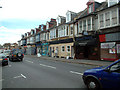
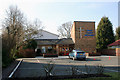
CR9 6BL offers a range of amenities within practical reach. Retail options include major chains like Tesco Croydon, Co-op 61 Lower, and Sainsburys Addiscombe, providing everyday shopping convenience. The area’s proximity to trams and rail stations ensures easy access to Croydon’s town centre and beyond, while nearby airports cater to occasional travel needs. The East India Estate Conservation Area adds a unique cultural dimension, with historic Victorian architecture and streets named after East India Company figures. Though the data does not mention parks or leisure facilities, the area’s integration with Croydon’s broader network suggests access to recreational spaces. The mix of retail, transport, and historical sites creates a lifestyle that balances practicality with character, appealing to those who value both convenience and heritage.
Amenities
Schools
The only school explicitly listed near CR9 6BL is Tunstall Nursery School, which provides early education for young children. No primary or secondary schools are mentioned in the data, meaning families with older children may need to look beyond the immediate area for schooling options. The absence of local schools could be a consideration for prospective buyers, particularly those planning to settle long-term. However, the nearby Addiscombe area, which includes the Addiscombe East Ward, may offer additional educational facilities. The lack of detailed information on school ratings or Ofsted reports means it is unclear how the local education provision compares to other parts of Croydon. For families prioritising proximity to schools, this area may require further research into nearby institutions.
| Rank | School | Type | Entry gender | Ages |
|---|
Explore more schools in this area
Go to Schools tabDemographics
The population of CR9 6BL is 1,758, with a median age of 47, indicating a mature community. The most common age group is adults aged 30–64, suggesting a stable population with strong family ties. Home ownership stands at 46%, meaning nearly half of residents own their homes, while the remaining 54% are likely to rent. The predominant accommodation type is houses, reflecting a more traditional housing stock compared to high-density areas. The predominant ethnic group is White, though no specific data on diversity or deprivation levels is provided. This suggests a relatively homogenous community, though further local surveys would be needed to confirm broader social dynamics. The age profile implies a mix of established residents and families, with fewer younger or elderly populations. The absence of specific deprivation data means it is unclear how economic factors might influence quality of life, but the median age and home ownership rates suggest a stable, middle-income demographic.
Household Size
Accommodation Type
Tenure
Ethnic Group
Religion
Household Composition
Age
Household Deprivation
NS-SEC
Explore more demographic insights in this area
Go to Demographics tabPlanning
Planning Constraints
- Flood RiskPremium
- Ramsar Wetland SitesPremium
- Area of Outstanding Natural BeautyPremium
- Protected Nature ReservePremium
- Protected WoodlandPremium