Area Overview for CR9 2NH
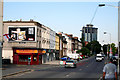
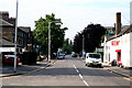
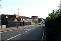
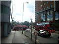
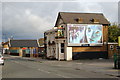
Photos of CR9 2NH


Area Information
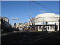
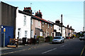
CR9 2NH is a small residential cluster in the London Borough of Croydon, home to 2,350 people. Nestled 7.8 miles south-east of Charing Cross, it lies within the historic Selhurst suburb, a name derived from Old English meaning “dwelling in a wood” or “dwelling where willows grow.” The area is part of the North Selhurst ward, historically in Surrey, and falls within the Croydon parliamentary constituency. Daily life here is shaped by its proximity to transport hubs like Selhurst Station and East Croydon Railway Station, which connect residents to London’s broader network. The community is compact, with a population density that reflects its role as a suburban extension of Croydon. While it lacks the sprawling urbanity of central London, its mix of retail, rail, and tram access offers convenience. The area’s history, including the 1865 opening of Selhurst Station and the legacy of the Croydon Canal, adds a layer of local character. For homebuyers, CR9 2NH represents a balance between suburban tranquillity and proximity to London’s infrastructure, though its small size means the immediate surroundings define much of its identity.
- Area Type
- Postcode
- Area Size
- Not available
- Population
- Not available
- Population Density
- Not available
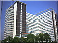
CR9 2NH’s property market is characterised by a 36% home ownership rate, with flats making up the majority of accommodation types. This indicates a rental-dominated market, typical of suburban areas near major transport hubs. The prevalence of flats suggests a housing stock developed for affordability and density, possibly dating from mid-20th century post-war building programmes. For buyers, this means limited opportunities for owner-occupied properties, with the market likely centred on smaller, older units. The small size of the postcode area means that property availability is constrained, and competition may be keen. Surrounding areas, such as Selhurst and East Croydon, offer broader options but come with higher prices. Investors or first-time buyers should consider the area’s reliance on rental demand, which could be influenced by nearby employment opportunities and transport links. The lack of high-end properties or luxury housing further positions CR9 2NH as a pragmatic choice for those prioritising location over property value.
House Prices in CR9 2NH
No properties found in this postcode.
Energy Efficiency in CR9 2NH
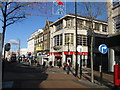
CR9 2NH offers a mix of retail, transport, and community amenities within walking or short transit distance. Local shops include Co-op 61 Lower, Tesco Croydon, and Co-op Selhurst, providing essential groceries and services. The area’s rail and tram networks connect residents to Croydon’s broader commercial and cultural hubs, including East Croydon’s retail parks and leisure facilities. While specific parks or recreational spaces are not listed in the data, the proximity to Selhurst Station suggests access to nearby green spaces or open areas in Croydon. The presence of multiple primary schools and transport links indicates a focus on family-friendly infrastructure, though dining and entertainment options are not detailed. The lifestyle here is defined by practicality, with amenities prioritising daily needs over luxury. Residents can expect a straightforward, functional environment where convenience is key, though the area’s small size means its character is heavily influenced by its immediate surroundings.
Amenities
Schools
CR9 2NH is served by multiple primary schools, all named Broadmead. These include Broadmead Junior School, Broadmead Nursery and Infant School, and Broadmead Primary School, with one of the latter receiving a “good” Ofsted rating. The concentration of primary schools suggests a focus on early education, catering to families with young children. The presence of multiple schools in close proximity may indicate a deliberate effort to meet local demand, though no secondary schools are listed in the data. For families, this provides a range of options, though the lack of diversity in school names and types could limit choice. The “good” rating for one school offers a benchmark of quality, but parents should verify current performance and capacity. The proximity of these schools to residential areas reinforces the area’s appeal for households with children, though the absence of higher education institutions or specialist provision may be a consideration for older students.
| Rank | School | Type | Entry gender | Ages |
|---|
Explore more schools in this area
Go to Schools tabDemographics
The population of CR9 2NH has a median age of 47, with the majority aged between 30 and 64 years. This suggests a community skewed towards middle-aged adults, likely including families and professionals. Home ownership is relatively low at 36%, indicating a higher proportion of renters compared to owner-occupiers. The predominant accommodation type is flats, reflecting a housing stock shaped by post-war development and modern rental demand. The predominant ethnic group is White, though no specific data on diversity or deprivation levels is provided. The age profile and home ownership figures imply a stable, settled population, with limited generational turnover. For quality of life, the absence of specific deprivation data means it is unclear whether the area faces challenges in services or infrastructure. However, the presence of multiple primary schools and transport links suggests a baseline of accessibility. The demographic profile is one of practicality, with residents prioritising proximity to amenities over property ownership.
Household Size
Accommodation Type
Tenure
Ethnic Group
Religion
Household Composition
Age
Household Deprivation
NS-SEC
Explore more demographic insights in this area
Go to Demographics tabPlanning
Planning Constraints
- Flood RiskPremium
- Ramsar Wetland SitesPremium
- Area of Outstanding Natural BeautyPremium
- Protected Nature ReservePremium
- Protected WoodlandPremium