Area Overview for CR5 2YH
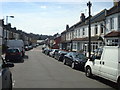
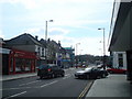
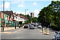
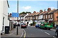
Photos of CR5 2YH


Area Information
Living in CR5 2YH offers a defined residential experience within the broader Coulsdon area of Croydon, Greater London. This specific postcode cluster encompasses a mere 3363 m², housing a population of 2597 people. Such a compact footprint creates a close-knit environment where neighbours are likely to know one another, yet the location retains strong connections to the wider district. The area sits within the London Borough of Croydon, historically part of Surrey, and forms a distinct residential hub rather than a sprawling suburb. Residents here benefit from a settled community atmosphere characterised by a small physical area and a stable population count. Daily life centres on accessibility to nearby transport links and local high streets, allowing for easy integration with the rhythms of Croydon and the wider South London network. The proximity to Coulsdon Town and surrounding wards means you remain connected to cultural attractions, major retailers, and regional employment centres without needing to travel far. For those seeking a focused living environment, this postcode delivers a practical solution. It is a place where the immediate surroundings are contained yet well-served by the infrastructure that defines modern London commuting and leisure activities.
- Area Type
- Postcode
- Area Size
- 3363 m²
- Population
- Not available
- Population Density
- Not available
The property market in CR5 2YH is heavily skewed towards flat living within a compact space. With 60% of residents being homeowners, the area consists largely of owner-occupied flats rather than a transient rental sector. This high ownership rate implies that many properties are well-maintained by their inhabitants, which can contribute to property values stability. The accommodation type is explicitly listed as flats, meaning you will primarily encounter apartment-style living or terraced converted units rather than spacious detached homes. Given the total area size of 3363 m², the housing stock is naturally dense, likely featuring estate or flat complexes. This density supports a convenient lifestyle but limits the availability of large gardens or standalone properties for those seeking expansive outdoor space. Buyers looking at homes in CR5 2YH should expect compact, efficient living arrangements designed for urban accessibility. The 60% ownership figure also suggests a market where lifetime tenures are common, leading to a community with strong roots rather than constant churn. Families or individuals purchasing here are investing in a district where the majority of neighbours have lived there for significant periods, fostering a predictable and stable market environment.
House Prices in CR5 2YH
No properties found in this postcode.
Energy Efficiency in CR5 2YH
Daily life in CR5 2YH is enriched by a convenient cluster of nearby amenities that cater to shopping, leisure, and travel needs. Within practical reach of residents, there are five notable retail options, including Aldi Coulsdon, Tesco Coulsdon, and Waitrose Coulsdon. These supermarkets provide daily essentials, fresh produce, and household goods without requiring a long journey. Transport connectivity is equally impressive, with access to five nearby rail stations namely Coulsdon Town, Coulsdon South, and Woodmansterne Station. Commuters enjoy frequent services that link the area to central London and the coast. For those preferring light rail travel, five metro stops are available, including Wandle Park Tram Stop, Lloyd Park Tram Stop, and Church Street Tram Stop. These bus and tram routes integrate seamlessly with the network of roadways and railways serving the wider Coulsdon area. The combination of high-street shopping and comprehensive public transport creates a self-sufficient environment where most daily necessities are accessible. You can run local errands, enjoy refreshments, or catch a train for work from your doorstep. This mix of commercial and transit facilities ensures a balanced lifestyle without the need to venture deep into Croydon town centre for basic requirements.
Amenities
Schools
| Rank | School | Type | Entry gender | Ages |
|---|
Explore more schools in this area
Go to Schools tabDemographics
The community profile of CR5 2YH reflects a mature demographic with a clear focus on stability. The median age is 47 years, and the most common age range is adults between 30 and 64 years. This indicates an area populated by working families, established professionals, and retirees rather than students or young singles. Home ownership stands at 60%, suggesting a solid base of long-term residents who have invested in the local real estate market. Two out of every three households own their property, which often correlates with higher levels of community engagement and lower transient housing turnover. The predominant ethnic group identifies as White, though the specific diversity percentages for other groups are not detailed in this dataset. Accommodation types in this specific postcode are primarily flats, distinguishing it from areas dominated by terraced or detached houses. This housing style aligns with the higher population density figure of 772,320 people per km² recorded for the area. A population of this size within such a small geographical space points to vertical living solutions being the norm. The data suggests a working-class to middle-class demographic that values proximity to amenities and solid investment properties over large single-status residences.
Household Size
Accommodation Type
Tenure
Ethnic Group
Religion
Household Composition
Age
Household Deprivation
NS-SEC
Explore more demographic insights in this area
Go to Demographics tabPlanning
Planning Constraints
- Flood RiskPremium
- Ramsar Wetland SitesPremium
- Area of Outstanding Natural BeautyPremium
- Protected Nature ReservePremium
- Protected WoodlandPremium