Area Overview for CR2 8YL
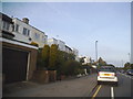
Photos of CR2 8YL

Area Information
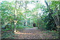
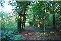
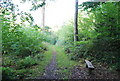
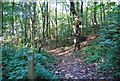
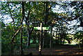
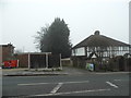
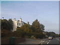
Living in CR2 8YL means being part of a small, residential postcode area within the London Borough of Croydon, specifically in the Selsdon Vale & Forestdale ward. This area, with a population of around 1,645, is characterised by suburban housing estates developed in the 20th century, including Selsdon Vale and Forestdale. The landscape is defined by curved streets and garden village planning, reflecting a focus on conservation from the outset. Historically, Selsdon was a detached part of Croydon’s parish, and its modern identity is shaped by 20th-century suburban expansion. The area contributes to local centres like Selsdon and Addington Village, offering a mix of residential tranquillity and proximity to amenities. Notable features include Selsdon Wood, a nature reserve preserved in the 1980s, and the Selsdon Park Hotel, which once formed part of the original estate. Residents benefit from a compact, community-oriented environment with access to nearby services and green spaces.
- Area Type
- Postcode
- Area Size
- Not available
- Population
- Not available
- Population Density
- Not available
CR2 8YL is predominantly an owner-occupied area, with 80% of homes owned by residents rather than rented. The accommodation type is primarily houses, which is typical of suburban areas with garden village planning. This suggests a housing stock that is largely traditional, with family homes rather than apartments or flats. The small postcode area means the property market is limited in scale, but the focus on houses indicates a demand for spacious, private living. For buyers, this implies a market where properties are likely to be long-term investments, with potential for stability in value. The high home ownership rate also suggests a community where residents are less transient, which can contribute to a sense of local identity. However, the limited size of the area may mean that buyers need to consider nearby suburbs for additional options.
House Prices in CR2 8YL
No properties found in this postcode.
Energy Efficiency in CR2 8YL
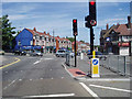
Life in CR2 8YL is supported by a range of amenities within practical reach. Residents can access five retail outlets, including Iceland Selsdon and Aldi, for everyday shopping. Three tram stops—Coombe Lane, Gravel Hill, and Addington Village—offer easy access to local transport networks, while rail stations at Sanderstead and Riddlesdown connect to broader London. The area is near London Biggin Hill Airport, useful for regional travel. Selsdon Wood, a preserved nature reserve, provides green space for leisure and recreation. The suburban layout, combined with nearby shops, transport, and natural areas, creates a balanced lifestyle. The presence of the Selsdon Park Hotel and historical sites adds character, while the proximity to Addington Village and Selsdon ensures a mix of residential and community-oriented living.
Amenities
Schools
The nearest school to CR2 8YL is Croydon High School, an independent institution. While no Ofsted rating is provided, the presence of an independent school suggests access to high-quality education, often associated with strong academic performance and extracurricular opportunities. Families in the area benefit from this option, though it may be more expensive than state schools. The data does not mention other schools, so it is unclear whether there are state-run alternatives nearby. For parents prioritising independent education, Croydon High School offers a clear advantage. However, those seeking a broader range of school types, including state-funded options, may need to look beyond the immediate area. The availability of this school aligns with the suburban character of CR2 8YL, where private education is a notable feature.
| Rank | School | Type | Entry gender | Ages |
|---|
Explore more schools in this area
Go to Schools tabDemographics
CR2 8YL has a median age of 47, with the majority of residents aged between 30 and 64 years. This suggests a mature, stable population, likely with established careers and family structures. Home ownership is high, at 80%, indicating a strong presence of long-term residents and a focus on property investment. The primary accommodation type is houses, which aligns with the suburban character of the area. The predominant ethnic group is White, though specific diversity figures are not provided. The age profile implies a community with a mix of middle-aged adults, potentially including retirees and families. With no data on deprivation levels, the quality of life here appears to be supported by the availability of local amenities, schools, and transport links. The high home ownership rate also suggests a sense of permanence and community cohesion.
Household Size
Accommodation Type
Tenure
Ethnic Group
Religion
Household Composition
Age
Household Deprivation
NS-SEC
Explore more demographic insights in this area
Go to Demographics tabPlanning
Planning Constraints
- Flood RiskPremium
- Ramsar Wetland SitesPremium
- Area of Outstanding Natural BeautyPremium
- Protected Nature ReservePremium
- Protected WoodlandPremium