Area Overview for CR0 2AF
Photos of CR0 2AF
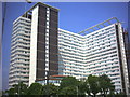
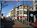


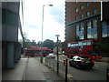


100 photos from this area
Area Information
Key information about the CR0 2AF including its size, population, and administrative classification.
- Area Type
- Postcode
- Area Size
- 7659 m²
- Population
- Not available
- Population Density
- Not available
House Prices in CR0 2AF
37
Properties
£198,385
Average Sold Price
£64,000
Lowest Price
£296,064
Highest Price
Showing 37 properties
| Address | Type | Beds | Baths | Last Sale Price | Last Sale Date | |
|---|---|---|---|---|---|---|
| 43, Woburn Court, Wellesley Road, Croydon, CR0 2AF | Maisonette | - | - | £265,000 | Mar 2024 | |
| 42, Woburn Court, Wellesley Road, Croydon, CR0 2AF | Flat | - | - | £251,000 | Feb 2024 | |
| 66, Woburn Court, Wellesley Road, Croydon, CR0 2AF | Maisonette | 2 | 1 | £285,000 | Feb 2024 | |
| 41, Woburn Court, Wellesley Road, Croydon, CR0 2AF | Maisonette | - | - | £280,000 | Nov 2022 | |
| 60, Woburn Court, Wellesley Road, Croydon, CR0 2AF | Maisonette | - | - | £272,000 | Sep 2020 | |
| 58, Woburn Court, Wellesley Road, Croydon, CR0 2AF | Flat | - | - | £225,000 | Jul 2020 | |
| 65, Woburn Court, Wellesley Road, Croydon, CR0 2AF | Flat | 1 | 1 | £260,500 | Feb 2020 | |
| 36, Woburn Court, Wellesley Road, Croydon, CR0 2AF | Maisonette | 5 | 1 | £265,500 | Oct 2019 | |
| 52, Woburn Court, Wellesley Road, Croydon, CR0 2AF | Maisonette | - | - | £296,064 | May 2019 | |
| 71, Woburn Court, Wellesley Road, Croydon, CR0 2AF | Maisonette | 2 | 1 | £285,000 | Apr 2019 |
Page 1 of 4
Energy Efficiency in CR0 2AF
Amenities
Schools
| Rank | School | Type | Entry gender | Ages |
|---|
Explore more schools in this area
Go to Schools tabDemographics
Household Size
Two person
most common
Accommodation Type
Flats
most common
Tenure
23
majority
Ethnic Group
White
most common
Religion
N/A
most common
Household Composition
N/A
most common
Age
47
median
Adults (30-64 years)
most common
Household Deprivation
N/A
with no deprivation
NS-SEC
41
in Lower managerial occupations
Explore more demographic insights in this area
Go to Demographics tabPlanning
Planning Constraints
- Flood RiskPremium
- Ramsar Wetland SitesPremium
- Area of Outstanding Natural BeautyPremium
- Protected Nature ReservePremium
- Protected WoodlandPremium