Area Overview for BR6 0HD
Photos of BR6 0HD
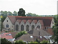
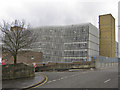
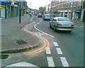
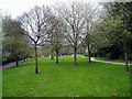
100 photos from this area
Area Information
Key information about the BR6 0HD including its size, population, and administrative classification.
- Area Type
- Postcode
- Area Size
- 8943 m²
- Population
- 1632
- Population Density
- 4297 people/km²
House Prices in BR6 0HD
27
Properties
£358,750
Average Sold Price
£134,000
Lowest Price
£517,500
Highest Price
Showing 27 properties
| Address | Type | Beds | Baths | Last Sale Price | Last Sale Date | |
|---|---|---|---|---|---|---|
| 18 White Hart Road, Orpington, BR6 0HD | Semi-detached | 3 | 1 | £495,000 | Sep 2021 | |
| 14 White Hart Road, Orpington, BR6 0HD | house | - | - | £467,000 | Mar 2021 | |
| 12 White Hart Road, Orpington, BR6 0HD | Semi-detached | 3 | 1 | £517,500 | Jan 2020 | |
| 20 White Hart Road, Orpington, BR6 0HD | Semi-detached | 3 | 1 | £512,000 | Mar 2019 | |
| 6 White Hart Road, Orpington, BR6 0HD | Semi-detached | 1 | 1 | £395,000 | Oct 2015 | |
| 8 White Hart Road, Orpington, BR6 0HD | Semi-detached | - | - | £186,000 | Apr 2003 | |
| 10 White Hart Road, Orpington, BR6 0HD | Semi-detached | - | - | £134,000 | Oct 2000 | |
| 28 White Hart Road, Orpington, BR6 0HD | Semi-detached | - | - | £163,500 | Aug 1998 | |
| Flat 4, 2A White Hart Road, Orpington, BR6 0HD | Flat | 1 | 1 | - | - | |
| Flat 6, Hart House, 1 White Hart Road, Orpington, BR6 0HD | Flat | 1 | 1 | - | - |
Page 1 of 3
Energy Efficiency in BR6 0HD
Amenities
Schools
| Rank | School | Type | Entry gender | Ages |
|---|
Explore more schools in this area
Go to Schools tabDemographics
Household Size
Family (3-5 people)
most common
Accommodation Type
Houses
most common
Tenure
74
majority
Ethnic Group
White
most common
Religion
N/A
most common
Household Composition
N/A
most common
Age
47
median
Adults (30-64 years)
most common
Household Deprivation
N/A
with no deprivation
NS-SEC
51
in Lower managerial occupations
Explore more demographic insights in this area
Go to Demographics tabPlanning
Planning Constraints
- Flood RiskPremium
- Ramsar Wetland SitesPremium
- Area of Outstanding Natural BeautyPremium
- Protected Nature ReservePremium
- Protected WoodlandPremium