Area Overview for BR4 0SL
Photos of BR4 0SL

Area Information
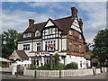
West Wickham, located within the BR4 0SL postcode, serves as an established residential cluster situated approximately 17 kilometres south-east of Charing Cross. This specific area covers 684 square metres of land within the London Borough of Bromley. Originally part of Kent before the formation of Greater London in 1965, the ward now houses a population of 1,757 residents. The settlement sits on a Roman road known as the London to Lewes Way, connecting it historically and geographically to nearby areas. Today, the High Street and the station area anchor the community, blending independent retail with modern convenience. The architecture is a unified mix of predominantly 1930s housing, reflecting one significant phase of suburban development that transformed the location from a small village into a London suburb by the mid-20th century. Residents live in an affluent environment characterised by a high level of home ownership and a consistent property layout. Whether you are moving to West Wickham for its historical charm or practical connectivity, the area offers a settled rhythm with clear boundaries defined by its proximity to Park Langley, Eden Park, and Bromley town centre.
- Area Type
- Postcode
- Area Size
- 684 m²
- Population
- Not available
- Population Density
- Not available
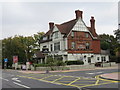
Homes in BR4 0SL represent a distinct segment of the London housing market, characterised by strong ownership and specific architectural eras. The market is overwhelmingly owner-occupied, with 66% of households holding their property outright or through mortgages. This contrasts sharply with high-rent zones and indicates a area where people settle down rather than transiently occupy units. The primary accommodation type found here is houses, reinforcing the appeal for those seeking traditional living spaces over flats or apartments. The housing stock is largely comprised of 1930s properties, a direct result of the rapid development that occurred after the electrification of the railway in 1926. This uniformity in building style gives West Wickham a cohesive visual identity. For homebuyers looking at this postcode, the high ownership rate suggests a competitive market where properties change hands less frequently than in share-sale areas. The presence of Wickham Court, a Grade I listed building, adds historical prestige to the surrounding residential streets. If you are considering purchasing, you are joining a market where residents have a deep emotional and financial investment in their streets.
House Prices in BR4 0SL
No properties found in this postcode.
Energy Efficiency in BR4 0SL
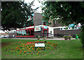
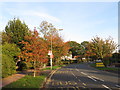
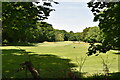
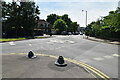
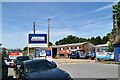
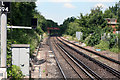
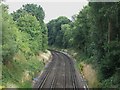
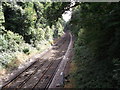
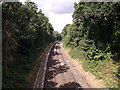
Daily life in BR4 0SL centres on the High Street and the immediate station area, offering a blend of local character and essential services. You will find five retail outlets nearby, including cook West, Sainsburys West, and M & S West Wickham SF. These supermarkets and smaller shops provide immediate access to groceries and daily necessities without the need to travel far. For leisure and transport, five railway stations and five tram stops serve the wider region, facilitating trips to Bromley and beyond. Biggin Hill Airport sits within practical reach for those requiring private aviation access. The area has retained a range of small independent shops alongside the modern supermarket developments, preserving a village-like atmosphere. West Wickham Common remains a notable outdoor feature; while much reduced from its former extent, a portion purchased by the Corporation of London in 1892 is still accessible. Historic landmarks like Wickham Court provide a focal point for the community. You can walk to the library or simply browse the streets of the High Street for local culture. This mix of historic architecture and modern retail creates a balanced environment for families.
Amenities
Schools
| Rank | School | Type | Entry gender | Ages |
|---|
Explore more schools in this area
Go to Schools tabDemographics
The community in BR4 0SL is defined by a mature demographic profile. The median age stands at 47 years, with adults between the ages of 30 and 64 representing the most common age range. This suggests a neighbourhood populated by established families and professionals rather than students or young singles. Home ownership is exceptionally high at 66%, indicating that a significant majority of residents have purchased their properties. The prevailing accommodation type consists of houses, which aligns with the ward's historical shift from village to suburb. The predominant ethnic group in the area is White, mirroring the demographic composition of the wider SouthEast. With a population of 1,757, the area maintains a small-town feel despite being integrated into Greater London. The absence of rental dominance and the focus on single-family homes create a stable social fabric where long-term residents form the core of the local community. You can expect a neighbourhood where neighbours often know each other due to the high density of owner-occupied dwellings.
Household Size
Accommodation Type
Tenure
Ethnic Group
Religion
Household Composition
Age
Household Deprivation
NS-SEC
Explore more demographic insights in this area
Go to Demographics tabPlanning
Planning Constraints
- Flood RiskPremium
- Ramsar Wetland SitesPremium
- Area of Outstanding Natural BeautyPremium
- Protected Nature ReservePremium
- Protected WoodlandPremium