Area Overview for BR3 4BE
Photos of BR3 4BE


Area Information
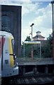
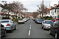
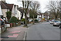
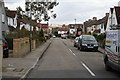
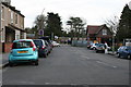
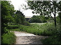
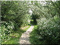
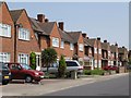
Living in BR3 4BE means residing in a compact residential cluster in the London Borough of Bromley, defined by its specific postcode boundaries. This small area covers just 636 square metres yet serves 1,690 residents, creating a tight-knit local community. The location sits near the borders of Clock House and Beckenham, where history meets modern suburban life. The Cator family once built a residence here between 1703 and 1723, though the original mansion was demolished in 1896 to make way for civic developments. Today, the immediate surroundings reflect the late Victorian era with the opening of Clock House railway station in 1890. You might encounter remnants of the original station booking hall or platform canopies as you navigate the streets. Daily life revolves around the Beckenham Road high street, which offers practical access to local shops and services. The area functions as a quiet, established suburban district rather than a bustling commercial hub. Residents benefit from proximity to the Mid-Kent Line, providing a direct link to central London. The density of 2,658,093 people per square kilometre is surprisingly high for such a small footprint, suggesting significant development or data interpretation nuances specific to this postcode designation. Regardless of the density metrics, the practical experience of living here involves a strong sense of place anchored by historic transport links and nearby green corridors.
- Area Type
- Postcode
- Area Size
- 636 m²
- Population
- Not available
- Population Density
- Not available
The property market in BR3 4BE is overwhelmingly characterised by owner-occupation, with 73% of households owning their homes. This statistic reveals a neighbourhood where residents are deeply invested in their properties and less likely to face the uncertainty of the出租 market. The accommodation type consists mainly of houses, which is consistent with the history of house building that began as early as 1885. These homes likely feature Victorian or Edwardian architecture, reflecting the era when the Mid-Kent Line electrification started in 1926. The small area size of 636 square metres contrasts with the population figure, suggesting a high concentration of dwellings in a specific cluster of streets. Fewer rental properties means buyers may face competition if moving to a specific street, as there is little turnover from short-term tenants. The 73% ownership rate also implies that most sales occur through standard conveyancing rather than Assignment of Tenancy or buy-to-let portfolios. When viewing homes near BR3 4BE, inspect the property history for connections to the original Cator family estate or the railway developments of the late 19th century. The market dynamics suggest a stable environment driven by families rather than investors seeking quick returns.
House Prices in BR3 4BE
Showing 13 properties
Energy Efficiency in BR3 4BE
Daily life in BR3 4BE offers immediate access to a variety of amenities, all conveniently located within walking or short driving distance. You can purchase groceries at Spar, Tesco Beckenham, or Co-op Eden, ensuring your basic needs are met without long journeys. The area is close to five retail outlets, providing variety in everyday shopping. For local travel,Clock House station offers a direct rail link, while the nearby Avenue Road, Harrington Road, and Arena tram stops provide seamless public transport options. Leicestershire Road or Beckenham Road serves as the main arterial route for access to broader Higham area services. You are also within reach of cultural sites such as the Biggin Hill Heritage gas collection depot and the famous Biggin Hill Airport flying museum. Greenwich Pier is available if you wish to take a leisure trip up the Thames. The area's history adds to the lifestyle, with remnants of the original Clock House booking hall adding character to the station. Five main rail stations and multiple tram stops mean you rarely need a car for daily commutes or social visits. This infrastructure supports a balanced life where you can work, shop, and socialise without feeling isolated from the wider city.
Amenities
Schools
| Rank | School | Type | Entry gender | Ages |
|---|
Explore more schools in this area
Go to Schools tabDemographics
The community within BR3 4BE is distinctly mature, with a median age of 47 years. Adults between the ages of 30 and 64 years make up the most common age range among residents. This demographic profile suggests a neighbourhood populated by families with established careers and children entering or leaving the school system. Home ownership is the dominant household arrangement, with 73% of residents owning their properties outright or with a mortgage. This high rate of equity indicates long-term settlement and financial stability among locals. The accommodation type is primarily houses, fitting the traditional suburban character of the Clock House ward. The predominant ethnic group is White, which aligns with the established nature of the area since its inception in the mid-20th century. There is a clear lack of transient populations, reinforcing the idea that people buy homes here to stay. The age structure also minimises the impact of empty nesters seeking downsizing, as the working-age majority remains active in the local economy. You will find a population that values stability and likely participates in local governance through the Bromley Borough Council elections first used in this ward in 1964.
Household Size
Accommodation Type
Tenure
Ethnic Group
Religion
Household Composition
Age
Household Deprivation
NS-SEC
Explore more demographic insights in this area
Go to Demographics tabPlanning
Planning Constraints
- Flood RiskPremium
- Ramsar Wetland SitesPremium
- Area of Outstanding Natural BeautyPremium
- Protected Nature ReservePremium
- Protected WoodlandPremium