Area Overview for BR2 9QX
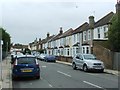
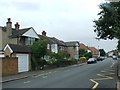
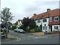
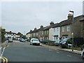
Photos of BR2 9QX
Area Information
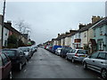
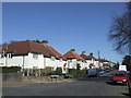
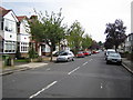
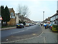
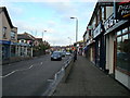
BR2 9QX is a compact residential postcode in the London Borough of Bromley, encompassing parts of the historically significant Bromley Common and Holwood Ward. With a population of 2,222 spread across 648 square metres, the area is densely populated yet retains a distinct character shaped by its history as a former common land. This small cluster of homes sits within a district that once straddled major routes between London and the southeast, now transformed by 19th-century railway expansion. Daily life here is defined by proximity to amenities, with five retail outlets including Co-op Bromley and Tesco, and easy access to rail and tram networks. The area’s mix of Victorian and 20th-century housing, combined with its strategic location near Biggin Hill Airport, offers a blend of suburban tranquility and urban connectivity. Residents benefit from a mature community, with a median age of 47 and a strong presence of owner-occupied homes, suggesting a stable, family-oriented environment. The area’s compact size means it is both a self-contained neighbourhood and a gateway to broader London.
- Area Type
- Postcode
- Area Size
- 648 m²
- Population
- 2222
- Population Density
- 3167 people/km²
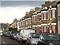
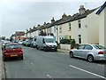
BR2 9QX is primarily an owner-occupied area, with 66% of homes owned by residents rather than rented. The accommodation type is predominantly houses, which is typical for suburban London boroughs like Bromley. This suggests a market skewed towards established properties rather than new-build apartments, offering buyers a range of family homes with garden space. The small area size means the housing stock is limited, and properties are likely to be in close proximity to one another. For buyers, this could mean competition for available homes, though the high home ownership rate may indicate a stable market with long-term residents less likely to sell. The presence of houses rather than flats also aligns with a preference for private outdoor space, which may appeal to those seeking a quieter, more traditional living environment.
House Prices in BR2 9QX
No properties found in this postcode.
Energy Efficiency in BR2 9QX
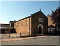
Living in BR2 9QX offers a mix of convenience and local character. The area is within walking distance of five retail outlets, including Co-op Bromley and Tesco, ensuring access to everyday shopping. Nearby rail and tram services connect residents to Bromley, London, and surrounding areas, while Biggin Hill Airport provides an alternative for travel. The historical Bromley Common area, though developed, retains pockets of green space, offering respite from urban density. The presence of St. Luke’s Church and Holy Trinity Church adds to the area’s heritage. For leisure, the proximity to Bromley’s shopping centres and transport hubs allows easy access to dining, entertainment, and cultural attractions. This blend of practical amenities and historical context creates a lifestyle that balances suburban comfort with urban accessibility.
Amenities
Schools
| Rank | School | Type | Entry gender | Ages |
|---|
Explore more schools in this area
Go to Schools tabDemographics
The population of BR2 9QX is predominantly adults aged 30–64, with a median age of 47, indicating a mature, established community. Home ownership is high at 66%, reflecting a strong presence of long-term residents and a focus on property as an investment. The area is characterised by houses rather than flats, aligning with its suburban nature. The predominant ethnic group is White, though specific diversity data is not provided. The high population density of 3.4 million people per square kilometre suggests a tightly knit community, though this may also mean limited space for new developments. The age profile suggests a balance between active professionals and retirees, with fewer young families compared to areas with higher birth rates. This demographic mix contributes to a steady, low-volatility housing market, with demand driven by those seeking stability in a well-connected suburb.
Household Size
Accommodation Type
Tenure
Ethnic Group
Religion
Household Composition
Age
Household Deprivation
NS-SEC
Explore more demographic insights in this area
Go to Demographics tabPlanning
Planning Constraints
- Flood RiskPremium
- Ramsar Wetland SitesPremium
- Area of Outstanding Natural BeautyPremium
- Protected Nature ReservePremium
- Protected WoodlandPremium