Area Overview for BR2 9NL
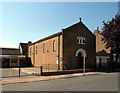
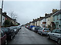
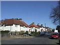
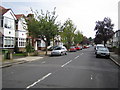
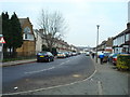
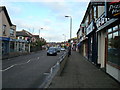
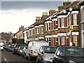
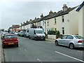
Photos of BR2 9NL
Area Information
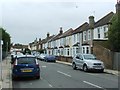
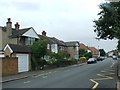
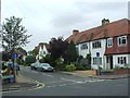
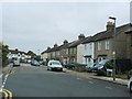
BR2 9NL is a compact residential postcode nestled in the London Borough of Bromley, a district 15 kilometres southeast of Charing Cross. With a population of 1,792 spread across 5,085 square metres, this area is densely populated yet retains historical character. Its origins trace to the 19th century, when the enclosure of Bromley Common in 1826 spurred suburban growth. The arrival of the railway in 1858 transformed the area into a commuter hub, with Victorian-era developments clustering around Chatterton Road and Raglan Road. Today, BR2 9NL blends older housing stock with modern infrastructure, offering a mix of residential tranquillity and proximity to London. The southern part of the common remains a green space, acting as a buffer between historic and contemporary developments. Residents benefit from nearby amenities, including multiple schools, rail links, and retail hubs. The area’s compact size means it is ideal for those seeking a well-connected yet low-density living environment, with easy access to Bromley’s broader offerings.
- Area Type
- Postcode
- Area Size
- 5085 m²
- Population
- 1792
- Population Density
- 6068 people/km²
BR2 9NL is predominantly an owner-occupied area, with 77% of properties owned by residents rather than rented. The accommodation type is largely houses, which is typical of suburban settings and contrasts with urban rental markets. This suggests a housing stock that prioritises family homes and long-term residency over short-term lettings. The small area size—just 5,085 square metres—means the property market is limited in scale, with competition likely among buyers. The high home ownership rate indicates a stable market, though the lack of data on property prices or recent transactions means potential buyers should investigate local estate agents for up-to-date figures. The presence of multiple rail stations and schools may enhance the area’s appeal, particularly for families seeking a balance between urban access and suburban comfort. Given the compact nature of the postcode, buyers should consider nearby areas for a broader range of options.
House Prices in BR2 9NL
No properties found in this postcode.
Energy Efficiency in BR2 9NL
The lifestyle in BR2 9NL is shaped by its proximity to retail, transport, and green spaces. Nearby shops include Co-op Bromley, Tesco Bromley, and Waitrose Bromley, providing everyday convenience. The area’s rail and tram networks connect residents to Bromley’s town centre and beyond, while two airports cater to those needing air travel. The southern part of Bromley Common, a historical green space, offers open areas for leisure, contrasting with the surrounding residential development. This mix of urban and natural environments supports a relaxed yet accessible lifestyle. The presence of multiple schools and community hubs suggests a family-oriented atmosphere, with amenities tailored to daily needs. The compact size of the postcode means residents can reach essential services quickly, enhancing convenience. Whether shopping, commuting, or enjoying nearby greenery, BR2 9NL offers a balanced blend of practicality and quality of life.
Amenities
Schools
BR2 9NL is served by three primary schools: Raglan Primary School, Raglan Junior School, and Raglan Infant School. A fourth school, also named Raglan Primary School, has an Ofsted rating of ‘good’, indicating a high standard of education. The concentration of primary schools suggests a family-friendly environment, with multiple options for parents to choose from. The presence of infant and junior schools ensures a seamless transition for children through their early education years. While no secondary schools are listed in the data, the proximity to Bromley’s broader educational network—such as Bromley College of Education—may offer additional opportunities. The ‘good’ Ofsted rating at one of the primary schools is a strong indicator of quality, which is a key consideration for families prioritising education. The density of schools also implies a community focused on raising children, with infrastructure tailored to support family needs.
| Rank | School | Type | Entry gender | Ages |
|---|
Explore more schools in this area
Go to Schools tabDemographics
The population of BR2 9NL has a median age of 47, with the majority of residents falling within the 30–64 age range. This suggests a mature, stable community with a focus on long-term residency. Home ownership is high at 77%, indicating a strong preference for property investment over rental living. The predominant accommodation type is houses, reflecting a suburban character rather than high-density housing. The White ethnic group constitutes the largest demographic, though specific data on other groups is not provided. The area’s population density of 352,407 people per square kilometre is exceptionally high, which may influence the sense of community and proximity to neighbours. This density, combined with a low crime risk (Safety Score: 79/100), suggests a secure, tightly knit environment where residents are likely to know their neighbours. The age profile indicates a balance between active professionals and retirees, contributing to a diverse yet cohesive social fabric.
Household Size
Accommodation Type
Tenure
Ethnic Group
Religion
Household Composition
Age
Household Deprivation
NS-SEC
Explore more demographic insights in this area
Go to Demographics tabPlanning
Planning Constraints
- Flood RiskPremium
- Ramsar Wetland SitesPremium
- Area of Outstanding Natural BeautyPremium
- Protected Nature ReservePremium
- Protected WoodlandPremium