Area Overview for BR1 5SU
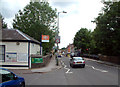
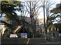
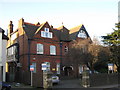
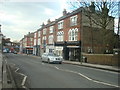
Photos of BR1 5SU


Area Information
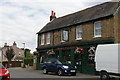
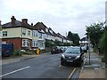
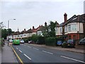
BR1 5SU is a small residential postcode area in England, home to 1850 residents. It is a compact cluster of properties, likely centred around a specific locality rather than a sprawling suburb. The area is distinct for its modest scale and the mix of amenities within reach. Residents here are predominantly adults aged 30–64, with a median age of 47, suggesting a community of established professionals and families. Daily life is shaped by proximity to retail, transport, and leisure options. The area’s small size means it is unlikely to have sprawling parks or large public spaces, but nearby stations and shops provide convenience. While BR1 5SU is not a major urban hub, its connectivity to rail, metro, and ferry services makes it a practical choice for commuters. The population density is low enough to avoid the congestion of larger cities, yet close enough to major infrastructure to support a balanced lifestyle. For those seeking a quiet, manageable area with access to essential services, BR1 5SU offers a snapshot of suburban living in a well-connected setting.
- Area Type
- Postcode
- Area Size
- Not available
- Population
- Not available
- Population Density
- Not available
BR1 5SU is a small area with a property market characterised by 50% home ownership and a predominance of houses. This suggests a mix of owner-occupied and rental properties, though the limited size of the area may restrict the availability of new developments. The focus on houses rather than flats or apartments implies a preference for larger, more private living spaces, which could appeal to families or individuals seeking space. However, the small scale of the area means buyers may need to consider nearby regions for more options. The 50% home ownership rate indicates a moderate balance between long-term residents and those in the rental market, but it also means competition for available properties could be keen. For buyers, this area may offer a quieter, less densely populated environment, though the lack of extensive property listings could make it challenging to find exactly what one is looking for. The market’s character is defined by its compactness and the types of homes available, which are largely traditional in style.
House Prices in BR1 5SU
No properties found in this postcode.
Energy Efficiency in BR1 5SU
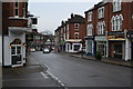
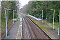
Living in BR1 5SU offers access to a range of amenities within close proximity. Retail options include Lidl Bromley, Tesco Bromley, and Co-op Downham, providing essential shopping and grocery needs. The area is served by multiple rail stations, including Sundridge Park and Grove Park, as well as metro stops like Beckenham Road Tram Stop, ensuring easy access to nearby towns and cities. Ferry services such as Greenwich Pier and Masthouse Terrace Pier add to the transport diversity. For those needing air travel, London City Airport and Biggin Hill Airport are within reach. The presence of multiple airports and transport hubs makes BR1 5SU a practical location for commuters and frequent travellers. While the area itself may not have expansive parks or leisure facilities, its connectivity to larger urban centres means residents can enjoy cultural, recreational, and dining options elsewhere. The combination of retail, transport, and nearby airports creates a lifestyle that balances convenience with accessibility to broader opportunities.
Amenities
Schools
| Rank | School | Type | Entry gender | Ages |
|---|
Explore more schools in this area
Go to Schools tabDemographics
The community in BR1 5SU is largely composed of adults aged 30–64, with a median age of 47. This suggests a population of working-age individuals and families, rather than a younger or elderly demographic. Home ownership rates stand at 50%, meaning half of residents live in properties they own, while the other half are likely renters. The accommodation type is predominantly houses, indicating a low-density residential area with larger properties rather than apartments or flats. The predominant ethnic group is White, though no specific data on diversity or deprivation is provided. This age profile and ownership split suggest a stable, middle-aged population with established careers and families. The lack of younger residents may mean fewer schools or childcare facilities, but the area’s proximity to rail and retail could compensate for such gaps. The demographic profile aligns with a community focused on practical living, with a balance between homeownership and rental options.
Household Size
Accommodation Type
Tenure
Ethnic Group
Religion
Household Composition
Age
Household Deprivation
NS-SEC
Explore more demographic insights in this area
Go to Demographics tabPlanning
Planning Constraints
- Flood RiskPremium
- Ramsar Wetland SitesPremium
- Area of Outstanding Natural BeautyPremium
- Protected Nature ReservePremium
- Protected WoodlandPremium