Area Overview for BR1 5EB
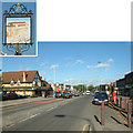
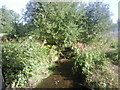
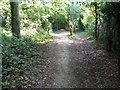
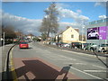
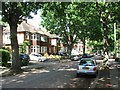
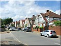
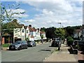
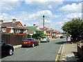
Photos of BR1 5EB
Area Information
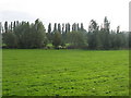
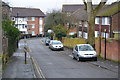
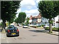
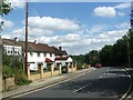
BR1 5EB is a compact residential postcode in southeast London, straddling parts of the London Borough of Lewisham and Bromley. With a population of 1,689 spread across 8,755 square metres, it is a densely populated yet historically distinct area. Originally farmland, it was transformed in the 1920s into the Downham Estate, a red-brick housing cluster designed to provide fresh air and green spaces for families displaced from overcrowded inner London. The area’s low-density layout, with front and back gardens, reflects post-WWI urban planning ideals. Today, it remains a suburban enclave with a mature community, offering a blend of residential tranquillity and proximity to Bromley, Catford, and central London. The presence of local institutions like the Good Shepherd RC School and Downham Tavern hints at a community rooted in tradition. Its compact size means residents are within walking distance of shops, parks, and transport links, making it a practical choice for those seeking a balance between suburban comfort and urban accessibility.
- Area Type
- Postcode
- Area Size
- 8755 m²
- Population
- 1689
- Population Density
- 6516 people/km²
The property market in BR1 5EB is characterised by a 43% home ownership rate, suggesting a balance between owner-occupied homes and rental properties. The area’s accommodation type is predominantly houses, reflecting its low-density, suburban layout. This contrasts with high-density urban areas, where flats dominate. The limited size of BR1 5EB means the housing stock is small, with few new developments likely. For buyers, this creates a tight market with limited options, though the existing homes—many built in the 1920s—offer historical charm and practical living space. The red-brick houses, with front and back gardens, cater to those prioritising private outdoor space. However, the small area size means buyers must consider nearby zones for more choices, though these may lack the same character.
House Prices in BR1 5EB
Showing 2 properties
| Address | Type | Beds | Baths | Last Sale Price | Last Sale Date | |
|---|---|---|---|---|---|---|
| Haka Sports Complex, Launcelot Road, Bromley, BR1 5EB | Leisure | - | - | - | - | |
| Mallory School, Launcelot Road, Bromley, BR1 5EB | commercial | - | - | - | - |
Energy Efficiency in BR1 5EB
Life in BR1 5EB is shaped by its proximity to a variety of amenities. Local shops include Co-op Downham, Sainsburys Lewisham Grove, and Tesco Grove, ensuring daily essentials are within reach. Parks such as Downham Fields and Beckenham Place Park offer green spaces for recreation, while historical sites like the Downham Tavern and Good Shepherd Church add cultural depth. The area’s transport links mean residents can easily access larger retail hubs, dining options, and leisure facilities beyond the postcode. The mix of retail, transport, and open spaces creates a lifestyle that balances convenience with suburban charm. For those who value walkability and access to both local and broader amenities, BR1 5EB provides a practical foundation for daily living.
Amenities
Schools
BR1 5EB is served by a range of primary schools, including Launcelot Primary School and Nursery (Ofsted rating: good) and Haberdashers’ Knights Academy (Ofsted rating: good), which are both academies. The Good Shepherd RC School has a satisfactory Ofsted rating, while Malory School is listed without a rating. This mix of state and academy schools offers families options, though the lack of detailed performance data for Malory may raise questions. The presence of multiple primary schools within proximity is a key advantage for families, ensuring access to education without long commutes. The Good Shepherd RC School, in particular, reflects the area’s historical ties to religious institutions. For parents, the combination of good-rated schools and local amenities makes BR1 5EB a viable choice for family-oriented living.
| Rank | School | Type | Entry gender | Ages |
|---|
Explore more schools in this area
Go to Schools tabDemographics
BR1 5EB has a median age of 47, with the majority of residents aged 30–64. This suggests a mature, settled community, likely with established careers and families. Home ownership rates stand at 43%, indicating a mix of owner-occupied properties and rental homes. The area is predominantly composed of houses, reflecting its low-density, suburban character. The predominant ethnic group is White, though no specific diversity statistics are provided. The high population density of 192,918 people per square kilometre underscores the area’s compact nature, which may influence the pace of daily life and community interactions. For those considering BR1 5EB, the demographic profile points to a neighbourhood where stability and familiarity are key, with limited scope for rapid change.
Household Size
Accommodation Type
Tenure
Ethnic Group
Religion
Household Composition
Age
Household Deprivation
NS-SEC
Explore more demographic insights in this area
Go to Demographics tabPlanning
Planning Constraints
- Flood RiskPremium
- Ramsar Wetland SitesPremium
- Area of Outstanding Natural BeautyPremium
- Protected Nature ReservePremium
- Protected WoodlandPremium