Area Overview for Bow East Ward
Photos of Bow East Ward
Area Information
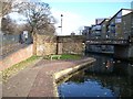
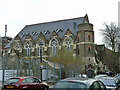
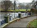
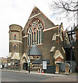
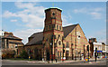
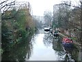
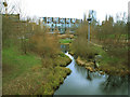
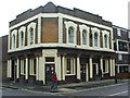
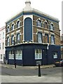
Living in Bow East Ward is defined by a distinctive blend of deep historical roots and modern connectivity. This electoral ward sits within the London Borough of Tower Hamlets, covering just 1.9 km². Despite its small footprint, it carries the legacy of a settlement that dates back to the 11th century and serves as a quiet node within East London, located approximately 4.6 miles east of the financial district. The area incorporates the suburbs of Old Ford and parts of Bethnal Green and Mile End. You will find the ward incorporates Old Ford, giving residents easy access to distinct neighbourhoods within a compact boundary. The community bears the weight of significant industrial and social history. The site of the famous Bryant and May match factory is now the enclave known as Bow Quarter, a gated residential complex that preserves the red-brick façade and clock tower of the original workers' rights epicentre. Nearby, Grove Hall Park offers green space on the grounds of what was once a private asylum, a site referenced in the work of Charles Dickens. Bow Church, founded in the 11th century and rebuilt by Sir Christopher Wren, stands as another enduring landmark. While specific contemporary economic drivers are not detailed, the area remains anchored by these historical structures and its position relative to Stepney and central London. For those seeking a location with tangible history, Bow East Ward provides a small, historically rich setting away from the busiest city centres.
- Area Type
- District Borough Unitary Ward
- Area Size
- 1.9 km²
- Population
- 3976
- Population Density
- 2132 people/km²
Demographics
The community profile of Bow East Ward reflects its status as a largely residential area with a specific age demographic. The median age for residents is 70, meaning half the population is younger than this age and half is older. This statistic indicates a community where older adults form the numerical midpoint, a fact that shapes local service needs and social dynamics. Home ownership stands at 33%, which means the majority of residents do not own their properties outright. Consequently, the rental sector likely dominates the local housing landscape compared to owner-occupied stock. Your household composition and accommodation types are currently recorded as being viewed in the total aggregate, meaning no specific breakdown distinguishes between single-person homes, families with children, or multi-generational living arrangements. The data notes the population density at 2,132 people per square kilometre, a figure that highlights the compact nature of this borough unitary ward. With a total population of 3,976, you will find a relatively small population concentrated in a limited footprint. The median age of 70 is notably high compared to the national average, suggesting a quieter residential atmosphere rather than one driven by young professionals or families with school-aged children. This demographic reality is the primary defining feature of who currently lives in Bow East Ward.
Household Size
Accommodation Type
Tenure
Ethnic Group
Religion
Household Composition
Age
Household Deprivation
NS-SEC
Explore more demographic insights in this area
Go to Demographics tabPlanning
Planning Constraints
- Flood RiskPremium
- Ramsar Wetland SitesPremium
- Area of Outstanding Natural BeautyPremium
- Protected Nature ReservePremium
- Protected WoodlandPremium
- Crime RiskPremium