Area Overview for Barnet
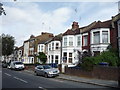
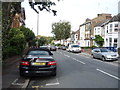
Photos of Barnet


Area Information
Living in Barnet offers a distinct experience within a built-up area spanning 65.4 km². The local population stands at 226,892 people, creating a community with a significant size that feels established yet manageable. You will find plenty of space for daily activities across this London Borough of Barnet, where the density of residents averages 3,468 people per square kilometre. This figure suggests a balanced environment without being cramped or overly sparse. The area functions as a major residential zone with clear boundaries and defined neighbourhoods. Prospective buyers often appreciate the scale of Barnet, which allows for a mix of housing styles within a cohesive framework. Every eighth kilometre contains roughly 3,500 residents, indicating a moderate spread of households. This siting provides a backdrop for a steady local economy and social fabric. When you consider homes in Barnet, you are choosing a settlement with a long history of growth. The size of the land and number of inhabitants work together to support local services and amenities. You can expect a familiar rhythm to life here, characterised by reliability and stability.
- Area Type
- District/Borough
- Area Size
- 65.4 km²
- Population
- 226892
- Population Density
- 3468 people/km²
Demographics
The community composition in Barnet reflects a mature demographic profile. The median age for residents is 70 years, which indicates a presence of many older households settling in the borough. This statistic shapes the local needs, from service provision to social engagement. You will encounter a population where age is the primary defining factor, with the total age range representing the bulk of the census data. Home ownership plays a central role in daily life, with 54 per cent of residents owning their properties outright or with a mortgage. This majority ownership rate suggests a stable community where long-term investment in property is common. The household composition data shows that families and single-person households coexist within the broader total population fabric. Accommodation types vary across the borough, though the total count reflects the standard housing stock available for these demographics. Diversity in the area contributes to the social texture, even if specific ethnic group breakdowns are not detailed in current reports. Religion data follows the same pattern, reflecting the broad faith landscape of the UK without isolating single dominant groups. Understanding these figures helps you gauge the social environment when thinking about living in Barnet.
Household Size
Accommodation Type
Tenure
Ethnic Group
Religion
Household Composition
Age
Household Deprivation
NS-SEC
Explore more demographic insights in this area
Go to Demographics tabPlanning
Planning Constraints
- Crime RiskPremium