Area Overview for WD6 4BD
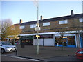
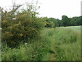
Photos of WD6 4BD
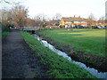
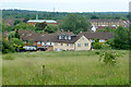
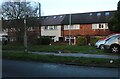
Area Information
Living in WD6 4BD defines a specific residential cluster within the broader Hatfield landscape. The area covers just 710 m² and holds a population of 1804 people. This constrained footprint creates a dense living environment where neighbours often know each other. You will find yourself part of a tightly knit community rather than a sprawling suburban expanse. The postcode area stands out for its high population density, which fluctuates at 2539180 people per square kilometre according to the latest metrics. These figures confirm that every square metre is utilised for housing. Residents here experience daily life in a concentrated setting where local services play a crucial role. The proximity of amenities like Co-op Boreham and Elstree & Borehamwood Railway Station is a practical necessity for daily activities. You do not travel far for essentials. The small size of the area means noise and local activity do not disperse widely. Instead, the character of the neighbourhood remains consistent. Whether you walk to the station or visit nearby schools, the journey is short. This creates a predictable routine for those committed to the location. The area functions efficiently without the sprawl common to wider WD6 zones. Your morning commute starts closer to home than in many neighbouring clusters.
- Area Type
- Postcode
- Area Size
- 710 m²
- Population
- 1804
- Population Density
- 3121 people/km²
Your search for homes in WD6 4BD focuses on a distinct segment of the property market. Houses dominate the accommodation type distribution for this specific postcode. This housing stock typically comprises detached or semi-detached buildings rather than flats or terraced rows. With 54% of residents owning their home, the area functions primarily as an owner-occupied zone. You will find more long-term owners than landlord rentals in this cluster of 1804 people. This high ownership rate usually stabilises prices and encourages careful maintenance of the exterior and garden. Buyers looking at WD6 4BD should expect properties suited to families or retirees rather than students. The limited area size of 710 m² restricts the total number of listings available. Competition for available properties can remain high despite the small inventory. The market here does not follow the rapid turnover seen in student-heavy zones like Edgware or Stanmore. Instead, transactions tend to be more considered and deliberate. Mortgage valuations for these houses often reflect the area's safety and transport links. You might find larger gardens and driveways common compared to dense city centre flats. The presence of local amenities like Morrisons Daily supports the need for substantial living spaces. This market sector lacks the infinite supply of rental units found elsewhere in Hertfordshire.
House Prices in WD6 4BD
Showing 4 properties
| Address | Type | Beds | Baths | Last Sale Price | Last Sale Date | |
|---|---|---|---|---|---|---|
| Flat 3, Sandy Lodge, Berwick Road, Borehamwood, WD6 4BD | Flat | - | - | - | - | |
| Flat 2, Sandy Lodge, Berwick Road, Borehamwood, WD6 4BD | Flat | - | - | - | - | |
| Flat 1, Sandy Lodge, Berwick Road, Borehamwood, WD6 4BD | Flat | - | - | - | - | |
| Flat 4, Sandy Lodge, Berwick Road, Borehamwood, WD6 4BD | Flat | - | - | - | - |
Energy Efficiency in WD6 4BD
Your daily life in WD6 4BD benefits from a curated list of nearby amenities. Five retail outlets operate within practical reach of the residential cluster. Co-op Boreham appears twice in the local roster, suggesting a strong presence. Morrisons Daily provides service for groceries and household requirements. You can visit these shops without a significant journey. Five railway stations including Elstree & Borehamwood Railway Station lie within the accessible radius. This rail network connects you directly to key employment hubs. Radlett Railway Station and Bricket Wood Railway Station add further depth to your travel options. Five metro stations such as Stanmore Station extend connectivity across the wider London region. High Barnet Station offers transport to the north. Your lifestyle relies on this mix of local commerce and regional transit. Dining options are not explicitly detailed beyond the retail category, but the density of services suggests convenience. The area supports a routine where errands run smoothly. You do not need a car for basic needs if you utilise the extensive rail and walking network. The presence of multiple Co-ops and food halls in Boreham ensures fresh produce is always available. This infrastructure serves the 1804 residents efficiently. Your weekends might involve a walk to the nearest station rather than a drive. The convenience of these amenities defines the pace of life here.
Amenities
Schools
Families living in WD6 4BD have access to specific educational institutions within practical reach. Parkside Community Primary School serves as a key local option for younger children. The school holds a good Ofsted rating, a clear indicator of educational quality. This institution likely captures students from the immediate 710 m² cluster before they transfer away. Great Brookmead School also operates nearby. This facility functions as a special school, catering to students with specific educational needs. The presence of a special school alongside a primary school suggests a holistic local education network. Teachers and staff in these institutions support a wide range of learning requirements. You can be confident that educational support is present close to your home. While secondary school options are not listed in the immediate vicinity, these local institutions form the first critical stage of schooling. The mix of a rated primary and a specialist secondary provision means families have direct access to state-resourced education without traveling far. Parents often prefer this proximity when choosing homes in WD6 4BD. The schools reflect the community's focus on stable, grounded upbringing rather than rapid, high-pressure academic environments. Local transport links like the Elstree & Borehamwood Railway Station make the journey to other institutions feasible if required.
| Rank | School | Type | Entry gender | Ages |
|---|
Explore more schools in this area
Go to Schools tabDemographics
The community in WD6 4BD centres on adults aged between 30 and 64 years. This age group forms the dominant demographic across the population of 1804 residents. The median age sits at 47, confirming that families with grown children and senior households prevail here. Home ownership is a strong pillar of this community, with 54% of residents owning their property outright or with a mortgage. The remaining households rely on rental or shared living arrangements. Houses constitute the primary form of accommodation throughout the postcode area. You are unlikely to find high-rise blocks or modern Zweckbau estates in this specific cluster. The predominant ethnic group identified for this zone is White. This homogeneity often correlates with established residential patterns in postcodes like WD6 4BD. The high level of homeownership suggests stability, as residents invest in long-term roots within their local environment. Single professionals or transient populations are less common than established families or retired couples. The age profile indicates a quieter evening compared to areas dominated by young adults. Local schools and community groups likely cater to this mature demographic. Your neighbours are probably seeking a stable, family-focused environment away from the vibrant nightlife of larger towns.
Household Size
Accommodation Type
Tenure
Ethnic Group
Religion
Household Composition
Age
Household Deprivation
NS-SEC
Explore more demographic insights in this area
Go to Demographics tabPlanning
Planning Constraints
- Flood RiskPremium
- Ramsar Wetland SitesPremium
- Area of Outstanding Natural BeautyPremium
- Protected Nature ReservePremium
- Protected WoodlandPremium