Area Overview for Ufford (East Suffolk)
Photos of Ufford (East Suffolk)
Area Information
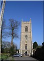
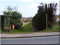
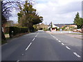
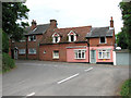
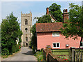
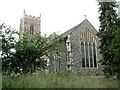
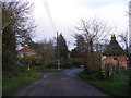
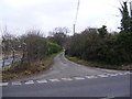
Ufford is a rural village and civil parish located in East Suffolk, positioned approximately 13 miles north-east of Ipswich. This built-up area spans 64.9 hectares and sits halfway between the larger towns of Woodbridge to the south and Wickham Market to the north, roughly two miles from each settlement. The village holds a 2021 census population of 593 residents within its built-up area, with broader parish estimates reaching around 1,080. Its origins trace back to Anglo-Saxon times, with the name recorded as "ufforda" in 1075. The area evolved from two distinct sections: "Upper Street," which developed along the coaching route to Great Yarmouth, and "Lower Street," which clustered around St Mary's Church and the Ufford Place estate. Living in Ufford means residing in a community with significant historical weight. The Church of St Mary, a Grade I listed building dating from the 11th century, stands as the oldest remaining structure. Crown Farmhouse on the High Street represents the oldest residential dwelling, a traditional Suffolk Long-house built in the 16th century. The lower village section, now designated a Conservation Area, features a collection of traditional thatched cottages and listed buildings including disused stocks and a whipping post. Many modern housing developments are interspersed amongst these historic structures rather than replacing them. The main road running through the village is the B1438, which replaced the former A12 trunk road following a bypass construction. This blend of preserved heritage and gradual evolution defines the character of daily life here.
- Area Type
- Built Up Area 250
- Area Size
- 64.9 hectares
- Population
- Not available
- Population Density
- Not available
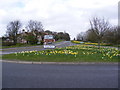
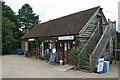
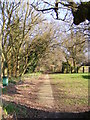
Residents of Ufford enjoy immediate access to essential services and local leisure facilities within walking distance. The village hosts two licensed premises: the Ufford Crown and the White Lion. These pubs serve as community anchors for social interaction. A community hall is available for local events, sports matches, and gatherings. The Ufford Sports Football Club operates local pitches supporting amateur athletics. For those seeking paid leisure, the Ufford Park Hotel functions as a country house hotel offering accommodation and dining. This hotel also manages an on-site golf course, providing a unique recreational option within the parish. Shopping infrastructure relies on nearby towns as the village itself lacks a large supermarket. The nearest retail outlets include a Morrisons Daily in Melton Woodbridge, a Spar store, and branches of the East of England Co-operative Co. These independent and chain stores are within practical reach for weekly groceries. The lower village section features a Recreation Ground offering space for outdoor activities. St Mary's Church grounds provide additional green space near the historic Grade I listed building. The Conservation Area status in the lower section protects the visual character of these amenities. Residents balance village tranquillity with a 20-minute drive to larger commercial hubs in Ipswich or Woodbridge for major retail trips.
Amenities
Schools
| Rank | School | Type | Entry gender | Ages |
|---|
Explore more schools in this area
Go to Schools tabDemographics
The community profile in Ufford reflects a stable society with a high rate of homeownership. Data indicates that 69% of residents own their homes outright or with a mortgage. This ownership level suggests the area appeals primarily to established homebuyers rather than transient tenants. The demographic age profile shows a median age of 70 years, making this one of the oldest communities in the region. The most common age range recorded in the society data is "Total," reflecting the aggregate population structure of the civil parish. Accommodation types in Ufford align with its rural nature, dominated by traditional properties rather than high-density flats. The village contains approximately 25 listed buildings, contributing to a housing stock where older structures predominate. Children and families are a small minority within this population, which skews heavily towards older households. The 2021 census figures for the built-up area show 593 residents, while the wider parish estimated population was 1,080 in 2019. This population size supports local amenities like two pubs, a community hall, and a local football club. The consistent presence of long-term residents and the high ownership rate create a settled atmosphere where the same families often remain for decades. Young professionals or empty nesters looking for a permanent rural base will find this demographic environment conducive to a quiet retirement or a slow-paced lifestyle.