Area Overview for Stokesby with Herringby
Photos of Stokesby with Herringby


Area Information
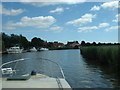
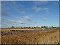
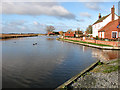
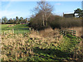
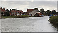
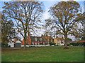
Stokesby with Herringby is a civil parish situated in England, covering an area of 8.6 square kilometres. This locality offers a specific character defined by its small geographic footprint and mature population. The area is not a large urban expansion but a defined settlement where life moves at a slower pace. You will find that the physical space is limited, which concentrates the community feel while restricting the variety of immediate local amenities found in larger towns. The name itself combines two distinct settlements, suggesting a history where Herringby and Stokesby have evolved together as a single administrative unit. Living in Stokesby with Herringby means accepting a village lifestyle where neighbours are likely to know each other over many years. The environment here is quiet, away from the noise and density of city centres. It is a place where the size of the land dictates the possibilities for building and development. You do not find the sprawling suburbs or high-rise blocks in this parish. Instead, you encounter a established residential area surrounded by green spaces typical of the English countryside. The 8.6 km² size ensures that distances are short, meaning a walk or a quick drive covers most local needs. This small scale creates a tight-knit environment where the pace of life is deliberately calm. Choosing to live in Stokesby with Herringby is a choice for simplicity and stability rather than urban energy.
- Area Type
- Parish
- Area Size
- 8.6 km²
- Population
- Not available
- Population Density
- Not available
Demographics
The community in Stokesby with Herringby has a distinct age profile that sets it apart from many modern growth areas. The median age within the parish stands at 70 years old. This figure indicates that over half the population is older than those three quarters of a century. You are looking primarily at an area populated by retirees and long-term residents rather than young families or university students. This demographic reality shapes the local shops, pubs, and social groups to suit an older clientele. When you examine household composition and accommodation types, the data reflects this settled nature of the population. Home ownership is the dominant housing tenure in this parish, with 71 percent of households owning their property outright or with a mortgage. This high level of ownership suggests stability, as owners are less likely to move frequently than tenants. The low rate of renting means the community is built around long-term roots rather than temporary contracts. The 70-year median age correlates directly with this ownership rate, as older generations have spent their careers accumulating property and then downgrading to smaller homes in their retirement. The housing stock is consequently adapted to the needs of this demographic, featuring single-storey bungalows or spacious two-storey houses that retain their value. Living in Stokesby with Herringby places you in a neighbourhood where the social fabric is woven by people who have stayed for decades.
Household Size
Accommodation Type
Tenure
Ethnic Group
Religion
Household Composition
Age
Household Deprivation
NS-SEC
Explore more demographic insights in this area
Go to Demographics tabPlanning
Planning Constraints
- Flood RiskPremium
- Ramsar Wetland SitesPremium
- Area of Outstanding Natural BeautyPremium
- Protected Nature ReservePremium
- Protected WoodlandPremium
- Crime RiskPremium