Area Overview for Stoke Ferry
Photos of Stoke Ferry


Area Information
Stoke Ferry is a small built-up area in England, spanning 70.4 hectares. Its compact size means it retains a close-knit character, with residents often familiar with one another. The area’s population is predominantly older, with a median age of 70, reflecting a community shaped by long-term residency. Living here offers a quiet, stable environment, ideal for those seeking a slower pace of life. The town’s proximity to nearby amenities, such as retail stores and an airport, balances local convenience with regional connectivity. Home ownership is high at 75%, suggesting a strong sense of community and investment in property. Daily life in Stoke Ferry is defined by its modest scale—local shops, schools, and open spaces form the backbone of its appeal. While it lacks the density of larger towns, this makes it a peaceful option for those prioritising safety and simplicity. The area’s distinctiveness lies in its blend of practicality and tranquillity, making it a viable choice for retirees or those seeking a low-maintenance lifestyle.
- Area Type
- Built Up Area 250
- Area Size
- 70.4 hectares
- Population
- Not available
- Population Density
- Not available
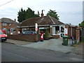
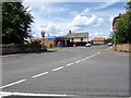
Residents of Stoke Ferry have access to a range of local amenities within practical reach. The area includes five retail outlets, such as Spar, Lidl Bexwell, and Spar Feltwell, providing essential shopping and convenience services. These stores cater to daily needs, from groceries to household items, ensuring residents can manage without long commutes. The presence of RAF Marham nearby adds to the area’s connectivity, offering regional travel options and potentially employment opportunities. While the data does not mention parks or leisure facilities, the compact size of Stoke Ferry suggests that local green spaces or community areas may be accessible. The combination of retail options and nearby transport links creates a lifestyle that balances self-sufficiency with regional access. For those valuing convenience and proximity to essential services, Stoke Ferry offers a practical, low-maintenance living environment.
Amenities
Schools
Stoke Ferry is served by two schools: The James Bradfield Church of England Community Primary School, which provides primary education, and All Saints Academy, an academy with a ‘good’ Ofsted rating. The presence of both a primary school and an academy offers families a choice between traditional and more academically focused education. The primary school likely caters to younger children, while the academy may provide a broader curriculum for older students. The ‘good’ rating for All Saints Academy indicates a satisfactory standard of education, though it does not reach the highest levels. Families prioritising school quality may find the combination of options in Stoke Ferry sufficient, though the lack of additional schools suggests limited alternatives for those seeking more choices. The schools are integral to the area’s infrastructure, supporting the needs of residents, particularly older families.
| Rank | School | Type | Entry gender | Ages |
|---|
Explore more schools in this area
Go to Schools tabDemographics
The demographic profile of Stoke Ferry is marked by an older population, with a median age of 70. This suggests a community where long-term residents dominate, potentially influencing local culture and services. Home ownership rates are robust at 75%, indicating a majority of residents live in properties they own rather than rent. The data does not specify household composition or accommodation types, but the high home ownership figure implies a stable, settled population. The area’s ethnic and religious diversity is not detailed, but the absence of specific figures means it is not a focus of the community’s identity. The age profile, with a median of 70, may affect local amenities and services, such as healthcare and leisure options. For prospective buyers, this demographic suggests a neighbourhood with a strong emphasis on comfort and continuity, though it may lack the dynamism of younger, more diverse areas.
Household Size
Accommodation Type
Tenure
Ethnic Group
Religion
Household Composition
Age
Household Deprivation
NS-SEC
Explore more demographic insights in this area
Go to Demographics tabPlanning
Planning Constraints
- Crime RiskPremium