Area Overview for Stewartby
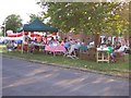
Photos of Stewartby


Area Information
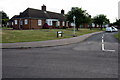
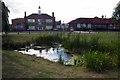
Stewartby, a built-up area in England covering 1.3 km², offers a compact yet well-connected environment for residents. With a median age of 70, the community is predominantly older, reflecting a demographic profile that prioritises stability and established living. The area’s home ownership rate of 80% underscores a strong sense of local investment, with many residents residing in properties they own. Daily life in Stewartby is shaped by its proximity to essential services, including five retail outlets such as Co-op Stewartby and Sainsburys Wootton, and accessible rail links like Stewartby Railway Station. The presence of educational institutions, including primary and sixth-form colleges, ensures families have options for schooling. While the area’s size is modest, its infrastructure supports practical living, with nearby Cranfield Airport offering regional travel connectivity. Stewartby is not a sprawling suburb but a focused community where convenience and familiarity define the rhythm of life.
- Area Type
- Built Up Area 250
- Area Size
- 1.3 km²
- Population
- Not available
- Population Density
- Not available
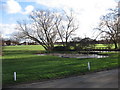
Living in Stewartby offers a blend of practicality and convenience through its accessible amenities. The area’s five retail outlets, including Co-op Stewartby and Sainsburys Wootton, provide everyday shopping needs within easy reach. Rail stations such as Stewartby and Millbrook ensure efficient travel to nearby destinations, while Cranfield Airport offers regional connectivity for those requiring air travel. Though the data does not specify parks or leisure facilities, the presence of multiple retail and transport options suggests a lifestyle focused on ease of access rather than expansive recreational spaces. The compact nature of the area means residents can meet most needs locally, though those seeking larger green spaces or cultural amenities may need to look further afield. The mix of shops, transport links, and nearby airports creates a functional environment for daily living.
Amenities
Schools
Stewartby’s proximity to a range of schools provides families with multiple educational options. Broadmead Lower School and Marston Vale Middle School cater to primary education, with the latter also operating as an academy rated “good” by Ofsted. For secondary and further education, Kimberley 16–19 Stem College offers specialised post-16 learning. The presence of both traditional state schools and academies suggests a diverse educational landscape, allowing parents to choose between established institutions and those with potentially distinct curricula or performance metrics. The “good” Ofsted rating at Marston Vale Middle School indicates a school performing above average, which could be a key consideration for families prioritising academic outcomes. This mix of school types ensures flexibility, whether parents seek a conventional school environment or one with a focus on STEM subjects.
| Rank | School | Type | Entry gender | Ages |
|---|
Explore more schools in this area
Go to Schools tabDemographics
Stewartby’s population has a median age of 70, indicating a community skewed towards older residents. The most common age range is listed as “Total,” suggesting aggregated data that does not break down specific cohorts. Home ownership here is exceptionally high at 80%, reflecting a demographic where property is primarily owner-occupied rather than rented. The accommodation types and household compositions are not detailed in the data, but the high ownership rate implies a stable, long-term resident base. Ethnicity and religious diversity are also not specified, though the data notes “total” for both categories, meaning no breakdown is available. This suggests a homogeneous community profile, though without further detail, it is difficult to assess the extent of cultural or social diversity. The absence of specific deprivation metrics means quality of life factors like access to services or economic hardship cannot be quantified here.
Household Size
Accommodation Type
Tenure
Ethnic Group
Religion
Household Composition
Age
Household Deprivation
NS-SEC
Explore more demographic insights in this area
Go to Demographics tabPlanning
Planning Constraints
- Crime RiskPremium