Area Overview for Stapleford Abbotts
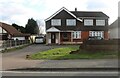
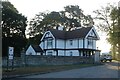
Photos of Stapleford Abbotts


Area Information
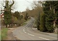
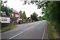
Stapleford Abbotts is a built-up area of 97 hectares, characterised by its practical scale and proximity to essential services. With a median age of 70, the population reflects a community that is predominantly older, shaping a distinct local rhythm. The area’s 79% home ownership rate suggests a stable, long-term resident base, with many properties likely to be family-owned or long-held. Daily life here is anchored by accessibility: within practical reach are five retail outlets, including Co-op Colliers and Sainsburys, and multiple transport hubs like Harold Wood Station and Grange Hill Underground. This blend of convenience and connectivity makes Stapleford Abbotts appealing for those prioritising ease of access to shopping, public transport, and nearby amenities. While the area lacks the density of a major city, its compact size ensures that essential services are never far. For buyers, the balance of affordability, practicality, and proximity to transport networks offers a pragmatic alternative to more sprawling suburbs.
- Area Type
- Built Up Area 250
- Area Size
- 97.0 hectares
- Population
- Not available
- Population Density
- Not available
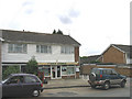
Residents of Stapleford Abbotts have access to a range of practical amenities within walking or short driving distance. Retail options include Co-op Colliers, Iceland Harold, and Sainsburys Harold, providing everyday shopping convenience. The area’s transport network is extensive, with five rail stations and three metro stops, including Harold Wood and Grange Hill Underground, facilitating easy travel to nearby towns and cities. While the data does not specify parks or leisure facilities, the presence of multiple transport hubs suggests a focus on connectivity over recreational spaces. Daily life here is defined by accessibility, with shopping, commuting, and essential services all within reach. The character of the area leans towards functionality, appealing to those who prioritise practicality over sprawling green spaces.
Amenities
Schools
| Rank | School | Type | Entry gender | Ages |
|---|
Explore more schools in this area
Go to Schools tabDemographics
The demographic profile of Stapleford Abbotts is defined by its median age of 70, indicating a population skewed towards older adults. This age group likely shapes the community’s dynamics, with a focus on stability and established routines. Home ownership is high, at 79%, suggesting a strong presence of long-term residents who have invested in property. The data does not specify household composition or accommodation types, but the overall figures imply a mix of family homes and single-occupancy residences. The absence of detailed diversity metrics means the area’s cultural or ethnic composition remains unquantified, though the 79% home ownership rate points to a community with a strong sense of place. For residents, this demographic structure may influence local services and amenities, with a focus on healthcare, leisure, and transport tailored to older adults.
Household Size
Accommodation Type
Tenure
Ethnic Group
Religion
Household Composition
Age
Household Deprivation
NS-SEC
Explore more demographic insights in this area
Go to Demographics tabPlanning
Planning Constraints
- Crime RiskPremium