Area Overview for Stanford East and Corringham Town Ward
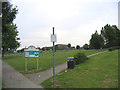
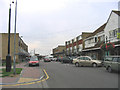
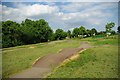
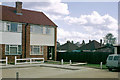
Photos of Stanford East and Corringham Town Ward

Area Information
Living in Stanford East and Corringham Town Ward means residing within a compact electoral ward that spans just 1.6 km². This location sits 24 miles east of London and 6 miles north-east of Grays, placing it firmly within the unitary authority of Thurrock. The area encompasses the town of Corringham and eastern parts of Stanford-le-Hope, situated near the Thames Estuary. Corringham was once an ancient parish linked to St Cedd, featuring a Saxon-origin church with herringbone stonework that remains a central landmark. The historic heart of the town is protected as one of Thurrock's seven conservation areas, preserving its unique character from the 7th century. Residents today enjoy proximity to the A13 road and are surrounded by established neighbourhoods including Ortu Corringham and areas near Giffards Primary School. While the Corringham Light Railway to the Kynoch munitions factory is no longer in operation, the town remains accessible via major arterial routes. Buying property here offers a specific slice of historical Essex living, distinct from the wider borough. You access a community defined by its conservation status and long-standing ties to the industrial history of the region, making it a singular choice for those seeking a rooted town experience.
- Area Type
- District Borough Unitary Ward
- Area Size
- 1.6 km²
- Population
- Not available
- Population Density
- Not available
Demographics
The community in Stanford East and Corringham Town Ward reflects a settled population with a median age of 70. This demographic profile indicates that a significant portion of residents are senior citizens, likely those who have owned their homes for many years. Sixty-six per cent of households own their homes outright or via mortgage, suggesting a high level of stability and long-term residence. The remaining third rely on rented accommodation or other tenure types, though exact breakdowns for these groups are not specified in current records. The ward's size of 1.6 km² fosters a closely knit environment where neighbours interact frequently, typical of villages within a larger urban authority. You will find families near schools such as Graham James Primary School and Ortu Gable Hall School, yet the overall age skew points toward retirees or those who have stayed for life. The area maintains distinct boundaries as an electoral ward, separating it from surrounding areas while preserving its own governance structure. Living here means engaging with a community where house ownership is the norm and where the population structure suggests a quiet, established lifestyle rather than a rapidly changing demographic landscape.
Household Size
Accommodation Type
Tenure
Ethnic Group
Religion
Household Composition
Age
Household Deprivation
NS-SEC
Explore more demographic insights in this area
Go to Demographics tabPlanning
Planning Constraints
- Flood RiskPremium
- Ramsar Wetland SitesPremium
- Area of Outstanding Natural BeautyPremium
- Protected Nature ReservePremium
- Protected WoodlandPremium
- Crime RiskPremium