Area Overview for St. Michael
Photos of St. Michael
Area Information
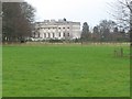
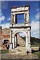
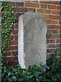
St. Michael is a civil parish in the St Albans district of Hertfordshire, covering an area of 21.0 km². The modern parish was established in 1974 following boundary reorganisation, with its main settlement located at Childwickbury. This area encompasses predominantly rural landscapes rather than dense urban development. Its history traces back to Saxon times, when St Michael's Church in St Albans served pilgrims visiting the nearby Abbey. The current parish boundaries differ from the original setup, as the historic church was transferred outside the parish limits during administrative changes. Despite this, the name remains a powerful link to the Anglo-Saxon past and the Roman basilica of Verulamium. You will find a quiet, countryside setting here, distinct from the bustling city centre of St Albans. The population in 2021 stood at 498 residents, indicating a small and settled community. Living in St. Michael offers a connection to ancient history within a peaceful, modern rural environment. The area provides a balance between historical significance and the tranquility of the Hertfordshire countryside.
- Area Type
- Parish
- Area Size
- 21.0 km²
- Population
- Not available
- Population Density
- Not available
Demographics
The community in St. Michael has a distinctly mature profile. The median age in the parish is 70 years old, reflecting a population dominated by older residents. Most household members fall within the broadest age categories recorded, suggesting a stable, long-term settlement. There are no significant data points indicating a high influx of young families or students in this specific parish. Home ownership is the norm rather than the exception, with 74% of residents owning their properties. This high ownership rate supports the view of a settled population likely downsizing or living permanently in these homes. The data does not provide a breakdown of specific household compositions such as singles, couples, or families, nor does it detail predominant ethnic groups or religious affiliations. Consequently, the demographic picture relies heavily on the age and ownership statistics which point towards a retirement-friendly environment. You are looking at a very senior cohort living in a rural setting. The lack of younger age groups in the data suggests this is not a dynamic hub for new arrivals but a resting place for those seeking a quiet life in Hertfordshire.
Household Size
Accommodation Type
Tenure
Ethnic Group
Religion
Household Composition
Age
Household Deprivation
NS-SEC
Explore more demographic insights in this area
Go to Demographics tabPlanning
Planning Constraints
- Flood RiskPremium
- Ramsar Wetland SitesPremium
- Area of Outstanding Natural BeautyPremium
- Protected Nature ReservePremium
- Protected WoodlandPremium
- Crime RiskPremium