Area Overview for St. John, Ilketshall
Photos of St. John, Ilketshall

Area Information
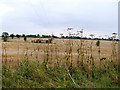
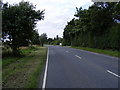
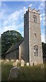
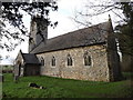
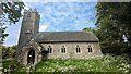
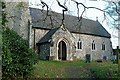
Living in St. John, Ilketshall means settling into a civil parish in Wangford, Suffolk, that spans just 3.1 km² of land. This small community sits within the historic Liberty of the Duke of Norfolk, offering a distinctly rural character far from urban congestion. The name itself reflects deep historical roots, deriving from Ulketil, an Earl of East Anglia in the eleventh century whose hall once held prominence in the region. Daily life here is anchored by the Church of St. John the Baptist, a building with origins reaching back to the 13th century. You will find the parish features notable architectural elements, including a round tower with an octagonal upper section and a Norman doorway. The church underwent significant renewal during the 19th century, with the porch rebuilt as recently as 1908. Residents also have quiet access to four bells housed within the tower. As a small parish, St. John, Ilketshall provides a contained environment where history meets the present. The community is governed as a civil parish, allowing for local management of these distinct geographic boundaries. For those seeking stability and a connection to Suffolk's heritage, this area offers a tangible link to the past without the noise of major cities.
- Area Type
- Parish
- Area Size
- 3.1 km²
- Population
- Not available
- Population Density
- Not available
Demographics
The community profile within St. John, Ilketshall reveals a settlement dominated by older residents. The median age for the population stands at 70, indicating that the area is largely inhabited by those in their later years. While the specific age range breakdown is not detailed beyond the total, the high median suggests a quiet demographic with limited young family presence. Home ownership is the defining characteristic of local living, with 75% of dwellings owned outright or with a mortgage. This high level of ownership points to an established population rather than a transient tenant estate. Household composition and accommodation type data indicate a traditional pattern of residency, though specific family structures are not broken out in the available figures. Ethnic and religious diversity statistics are not listed in the provided dataset, but the socioeconomic profile remains clear. The combination of a high age ceiling and strong home ownership rates paints a picture of stability. People living here have likely settled permanently, often passing through life stages closer to retirement. This demographic reality means services and community support often cater to an older constituency. The area represents a predictable social environment where long-term residents form the core of the neighbourhood fabric.
Household Size
Accommodation Type
Tenure
Ethnic Group
Religion
Household Composition
Age
Household Deprivation
NS-SEC
Explore more demographic insights in this area
Go to Demographics tabPlanning
Planning Constraints
- Flood RiskPremium
- Ramsar Wetland SitesPremium
- Area of Outstanding Natural BeautyPremium
- Protected Nature ReservePremium
- Protected WoodlandPremium
- Crime RiskPremium