Area Overview for SS7 1DE
Photos of SS7 1DE
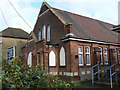
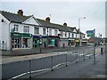
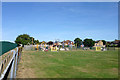
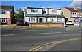
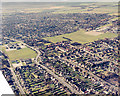
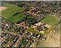
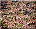
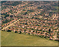
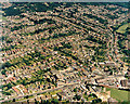
10 photos from this area
Area Information
Key information about the SS7 1DE including its size, population, and administrative classification.
- Area Type
- Postcode
- Area Size
- 1.1 hectares
- Population
- 1627
- Population Density
- 5305 people/km²
House Prices in SS7 1DE
32
Properties
£277,166
Average Sold Price
£46,500
Lowest Price
£495,000
Highest Price
Showing 32 properties
| Address | Type | Beds | Baths | Last Sale Price | Last Sale Date | |
|---|---|---|---|---|---|---|
| 17A Clarence Road, South Benfleet, Benfleet, SS7 1DE | house | - | - | £495,000 | May 2025 | |
| 5B Clarence Road, South Benfleet, Benfleet, SS7 1DE | Flat | 2 | 1 | £275,000 | Feb 2025 | |
| 21 Clarence Road, South Benfleet, Benfleet, SS7 1DE | Semi-detached | 4 | 1 | £380,000 | Aug 2024 | |
| 3B Clarence Road, South Benfleet, Benfleet, SS7 1DE | Flat | - | - | £245,000 | Feb 2022 | |
| 35 Clarence Road, South Benfleet, Benfleet, SS7 1DE | house | - | - | £300,000 | Sep 2021 | |
| 1 Clarence Road, South Benfleet, Benfleet, SS7 1DE | Bungalow | 4 | 2 | £491,000 | Oct 2020 | |
| 37 Clarence Road, South Benfleet, Benfleet, SS7 1DE | Semi-detached | 3 | - | £325,000 | Feb 2019 | |
| 1B Clarence Road, South Benfleet, Benfleet, SS7 1DE | Semi-detached | 4 | 2 | £422,500 | Nov 2018 | |
| 1A Clarence Road, South Benfleet, Benfleet, SS7 1DE | house | - | - | £430,500 | Oct 2018 | |
| 15 Clarence Road, South Benfleet, Benfleet, SS7 1DE | house | - | - | £405,000 | Jul 2018 |
Page 1 of 4
Energy Efficiency in SS7 1DE
Amenities
Schools
| Rank | School | Type | Entry gender | Ages |
|---|
Explore more schools in this area
Go to Schools tabDemographics
Household Size
Family (3-5 people)
most common
Accommodation Type
Houses
most common
Tenure
86
majority
Ethnic Group
White
most common
Religion
N/A
most common
Household Composition
N/A
most common
Age
47
median
Adults (30-64 years)
most common
Household Deprivation
N/A
with no deprivation
NS-SEC
35
in Lower managerial occupations
Explore more demographic insights in this area
Go to Demographics tabPlanning
Planning Constraints
- Flood RiskPremium
- Ramsar Wetland SitesPremium
- Area of Outstanding Natural BeautyPremium
- Protected Nature ReservePremium
- Protected WoodlandPremium