Area Overview for SS15 5GX
Photos of SS15 5GX

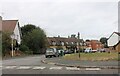
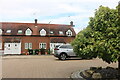
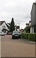
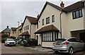

20 photos from this area
Area Information
Key information about the SS15 5GX including its size, population, and administrative classification.
- Area Type
- Postcode
- Area Size
- 4.3 hectares
- Population
- 1821
- Population Density
- 275 people/km²
House Prices in SS15 5GX
32
Properties
£234,656
Average Sold Price
£82,000
Lowest Price
£505,000
Highest Price
Showing 32 properties
| Address | Type | Beds | Baths | Last Sale Price | Last Sale Date | |
|---|---|---|---|---|---|---|
| 29 Thistle Close, Noak Bridge, Basildon, SS15 5GX | Terraced | 2 | 1 | £320,000 | Aug 2025 | |
| 23 Thistle Close, Noak Bridge, Basildon, SS15 5GX | Terraced | 2 | 1 | £315,000 | Apr 2024 | |
| 24 Thistle Close, Noak Bridge, Basildon, SS15 5GX | Terraced | 3 | 1 | £390,000 | May 2023 | |
| 33 Thistle Close, Noak Bridge, Basildon, SS15 5GX | Detached | 3 | 2 | £505,000 | Sep 2022 | |
| 18 Thistle Close, Noak Bridge, Basildon, SS15 5GX | Retail | 3 | 2 | £405,000 | Aug 2022 | |
| 21 Thistle Close, Noak Bridge, Basildon, SS15 5GX | house | 2 | - | £322,000 | Sep 2021 | |
| 3 Thistle Close, Noak Bridge, Basildon, SS15 5GX | Terraced | 2 | 1 | £305,000 | Feb 2021 | |
| 19 Thistle Close, Noak Bridge, Basildon, SS15 5GX | house | 2 | - | £277,500 | Jun 2020 | |
| 32 Thistle Close, Noak Bridge, Basildon, SS15 5GX | house | - | - | £320,000 | Jul 2019 | |
| 16 Thistle Close, Noak Bridge, Basildon, SS15 5GX | house | - | - | £315,000 | Feb 2018 |
Page 1 of 4
Energy Efficiency in SS15 5GX
Amenities
Schools
| Rank | School | Type | Entry gender | Ages |
|---|
Explore more schools in this area
Go to Schools tabDemographics
Household Size
Family (3-5 people)
most common
Accommodation Type
Houses
most common
Tenure
87
majority
Ethnic Group
White
most common
Religion
N/A
most common
Household Composition
N/A
most common
Age
47
median
Adults (30-64 years)
most common
Household Deprivation
N/A
with no deprivation
NS-SEC
36
in Lower managerial occupations
Explore more demographic insights in this area
Go to Demographics tabPlanning
Planning Constraints
- Flood RiskPremium
- Ramsar Wetland SitesPremium
- Area of Outstanding Natural BeautyPremium
- Protected Nature ReservePremium
- Protected WoodlandPremium