Area Overview for Shillington
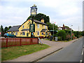
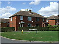
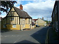
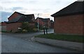
Photos of Shillington


Area Information
Shillington is a built-up area in England covering 91.9 hectares, offering a compact yet functional living environment. With a median age of 70, the community is predominantly older, suggesting a settled population with established roots. The area’s size is modest, which may contribute to a close-knit feel, though it lacks the density of larger towns. For residents, daily life is shaped by proximity to nearby amenities, including retail outlets and rail stations. The presence of Shillington Lower School, rated good by Ofsted, provides a reliable primary education option. While the area’s demographic profile is defined by its age profile, it remains connected to broader regional networks via transport links. Living in Shillington means prioritising convenience over sprawling landscapes, with homes and services clustered within a practical radius. The area’s character is defined by its balance of simplicity and accessibility, making it suitable for those seeking a quieter, community-focused lifestyle.
- Area Type
- Built Up Area 250
- Area Size
- 91.9 hectares
- Population
- Not available
- Population Density
- Not available
Shillington’s proximity to amenities like Budgens Meppershall, Tesco Shefford, and Co-op Silsoe ensures everyday shopping needs are met within reach. These retail outlets, combined with nearby rail stations, create a functional lifestyle for residents. While the area lacks detailed data on parks or leisure facilities, the presence of multiple retail and transport hubs suggests a focus on practicality over expansive recreational spaces. The convenience of nearby supermarkets and rail access supports a lifestyle centred on ease of movement and daily essentials. For those valuing accessibility over large-scale amenities, Shillington’s layout offers a straightforward, no-frills approach to living.
Amenities
Schools
The nearest school to Shillington is Shillington Lower School, a primary institution with a good Ofsted rating. This provides a reliable option for families with younger children, though no secondary schools are listed in the data. The absence of higher education facilities nearby means students may need to commute to nearby towns for secondary schooling. The presence of a primary school with a positive rating is a key selling point for families prioritising early education quality. However, the lack of detailed information on school catchment areas or additional educational facilities limits a fuller picture. For buyers, the school’s rating is a positive factor, but the need to consider secondary education options beyond Shillington is critical.
| Rank | School | Type | Entry gender | Ages |
|---|
Explore more schools in this area
Go to Schools tabDemographics
Shillington’s population is marked by a median age of 70, indicating a community skewed towards older adults. The most common age range is listed as "Age: Total," suggesting aggregated data rather than specific breakdowns. Home ownership here is robust, with 71% of residents owning their homes, reflecting a stable, long-term demographic. Accommodation types and household compositions are not specified, but the high home ownership rate implies a mix of family homes and single-occupancy properties. The area’s predominant ethnic group and religious composition are not detailed, but the data highlights a lack of specific diversity metrics. This suggests a homogeneous community, though the absence of detailed statistics means broader conclusions are speculative. For buyers, the age profile and ownership rates indicate a mature market with potential for long-term residency, though younger families may find fewer targeted amenities.
Household Size
Accommodation Type
Tenure
Ethnic Group
Religion
Household Composition
Age
Household Deprivation
NS-SEC
Explore more demographic insights in this area
Go to Demographics tabPlanning
Planning Constraints
- Crime RiskPremium