Area Overview for SG8 5GY
Photos of SG8 5GY


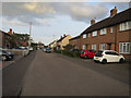

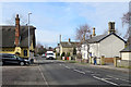
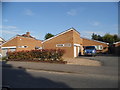


31 photos from this area
Area Information
Key information about the SG8 5GY including its size, population, and administrative classification.
- Area Type
- Postcode
- Area Size
- 3.6 hectares
- Population
- 1920
- Population Density
- 1392 people/km²
House Prices in SG8 5GY
26
Properties
£520,308
Average Sold Price
£165,580
Lowest Price
£749,950
Highest Price
Showing 26 properties
| Address | Type | Beds | Baths | Last Sale Price | Last Sale Date | |
|---|---|---|---|---|---|---|
| 20 Robinson Gardens, Bassingbourn Cum Kneesworth, SG8 5GY | Detached | 4 | 2 | £660,000 | Aug 2024 | |
| 26 Robinson Gardens, Bassingbourn Cum Kneesworth, SG8 5GY | Detached | 5 | 3 | £730,000 | Jan 2023 | |
| 7 Robinson Gardens, Bassingbourn Cum Kneesworth, SG8 5GY | house | - | - | £165,580 | Oct 2020 | |
| 15 Robinson Gardens, Bassingbourn Cum Kneesworth, SG8 5GY | Detached | 4 | 2 | £495,000 | Jun 2020 | |
| 18 Robinson Gardens, Bassingbourn Cum Kneesworth, SG8 5GY | house | - | - | £670,000 | Mar 2020 | |
| 16 Robinson Gardens, Bassingbourn Cum Kneesworth, SG8 5GY | Detached | 6 | 3 | £549,950 | Jan 2020 | |
| 19 Robinson Gardens, Bassingbourn Cum Kneesworth, SG8 5GY | Detached | 5 | 2 | £715,000 | Dec 2019 | |
| 12 Robinson Gardens, Bassingbourn Cum Kneesworth, SG8 5GY | house | - | - | £389,950 | Dec 2019 | |
| 17 Robinson Gardens, Bassingbourn Cum Kneesworth, SG8 5GY | house | - | - | £749,950 | Dec 2019 | |
| 14 Robinson Gardens, Bassingbourn Cum Kneesworth, SG8 5GY | house | - | - | £360,000 | Dec 2019 |
Page 1 of 3
Energy Efficiency in SG8 5GY
Amenities
Schools
| Rank | School | Type | Entry gender | Ages |
|---|
Explore more schools in this area
Go to Schools tabDemographics
Household Size
Family (3-5 people)
most common
Accommodation Type
Houses
most common
Tenure
67
majority
Ethnic Group
White
most common
Religion
N/A
most common
Household Composition
N/A
most common
Age
47
median
Adults (30-64 years)
most common
Household Deprivation
N/A
with no deprivation
NS-SEC
34
in Lower managerial occupations
Explore more demographic insights in this area
Go to Demographics tabPlanning
Planning Constraints
- Flood RiskPremium
- Ramsar Wetland SitesPremium
- Area of Outstanding Natural BeautyPremium
- Protected Nature ReservePremium
- Protected WoodlandPremium