Area Overview for SG5 4SF
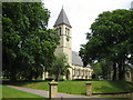
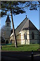
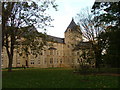
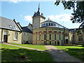
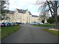
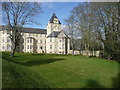
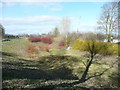
Photos of SG5 4SF
Area Information
Living in SG5 4SF means residing within a specific residential cluster that spans just 4,122 square metres. This concentrated postcode area represents a tight-knit community of 2,893 people, resulting in a population density of 1,172 people per kilometre. The location is defined by its compact nature, where residents navigate a local environment characterised by close proximity to neighbours and established infrastructure. Daily life here revolves around a stable residential setting that balances living space with community access. The area functions as a self-contained cluster where the majority of residents live in houses rather than high-density blocks. This structure suggests a suburban rather than urban lifestyle, prioritising ground-level living and direct access to gardens or private outdoor spaces. You will find that the built environment accommodates a mature demographic, reflecting a neighbourhood where long-term settlement is common. The population profile indicates an area where families and established individuals have put down roots for over several decades. For those considering homes in SG5 4SF, the physical footprint of the postcode offers a quiet, grounded experience. The limited area size dictates that amenities and transport links are within a reasonable步行 distance, reducing the need for extensive daily travel. You move through streets where the history of the land and the community are visibly present in every building. This is a place where the scale of the neighbourhood matches the pace of life, offering privacy without complete isolation from local services.
- Area Type
- Postcode
- Area Size
- 4122 m²
- Population
- 2893
- Population Density
- 1172 people/km²
The property market in SG5 4SF is defined by a strong inclination towards ownership. With 81 per cent of households owning their homes, the area functions primarily as a zone for owner-occupiers rather than a rental hub. This statistic indicates that the local estate market circulates bought and sold properties more than long-term tenancies. When viewing homes in SG5 4SF, you will encounter a stock where previous owners have spent significant time and capital on improvements. The predominant accommodation type is houses, which dictates the visual and structural character of the neighbourhood. This housing strategy excludes large flats or high-rise buildings, ensuring that the skyline remains low and the streets retain a traditional residential feel. Buyers looking at this postcode should expect to engage with sellers who have lived there for extended periods. The high ownership percentage also suggests that the market may experience fewer short-term rentals, providing a consistent environment for neighbours. Even though the postcode covers a small geographical area of 4,122 square metres, it connects seamlessly with the wider SG5 region property trends. The local market reflects the needs of families and couples who can afford to purchase rather than rent. This stability often protects property values from the volatility seen in rental-heavy areas. If you are looking to buy, the high density of owner-occupiers means you are entering a community of peers with similar financial footing and local investment interests.
House Prices in SG5 4SF
Showing 2 properties
| Address | Type | Beds | Baths | Last Sale Price | Last Sale Date | |
|---|---|---|---|---|---|---|
| East Lodge, Hitchin Road, Fairfield, SG5 4SF | Detached | 5 | 3 | £1,050,000 | Dec 2019 | |
| Garden House, East Lodge, Hitchin Road, Fairfield, SG5 4SF | Detached | 5 | 3 | - | - |
Energy Efficiency in SG5 4SF
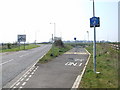
Living in SG5 4SF offers access to practical amenities clustered within a short distance. Residents benefit from five major retail locations, including Tesco Fairfield, Co-op Stotfold, and Tesco Letchworth. These supermarkets allow you to handle weekly shopping and household necessities without driving far. The presence of Tesco Fairfield and Co-op Stotfold specifically highlights that your daily grocery needs are met locally, saving time on transport. Transport options are equally convenient, with five rail stations supporting your weekly schedule. Letchworth Railway Station, Arlesey Railway Station, and Baldock Railway Station are all designated as nearby hubs. This network ensures that travel to other towns or the wider region is straightforward via train. You can manage appointments, social visits, or leisure trips using public transport or by driving to these specific stations. The amenity mix creates a self-sufficient lifestyle where most conveniences are just a few steps or a short drive away. The area size of 4,122 square metres means these amenities are physically close to your doorstep. You will not find sprawling landscapes here, but rather a focused collection of services designed for residents. The availability of these specific retailers and stations guarantees that living in SG5 4SF does not mean sacrificing convenience for quietness. Your lifestyle remains active and connected while enjoying the stability of a high-ownership neighbourhood.
Amenities
Schools
Education near SG5 4SF is primarily served by local primary institutions designed for younger children. You have access to Fairfield Park Lower School, which is situated nearby and currently holds a Good Ofsted rating. This designation signifies that the school meets expected standards of teaching, leadership, and student progress. For families in the area, this provides a reliable educational option without the need for long commutes to secondary hubs. The presence of a lower school suggests that the local cluster caters specifically to the primary education phase. Parents in SG5 4SF must plan for future schooling beyond this stage, as there are no secondary schools listed within the immediate data parameters. However, the proximity of Fairfield Park Lower School ensures that early education is convenient and of a verified quality. The single-school focus in this dataset highlights a specific service breadth tailored to the area's younger demographic. When considering schools near SG5 4SF, families benefit from a provider with a recognised standard of performance. The Good rating from Ofsted is a concrete indicator that the institution supports effective learning outcomes. While the area's small population of 2,893 people limits the diversity of school choices within the immediate postcode, the available options are of a high standard. You can expect a learning environment that complies with national regulations and respects child welfare standards.
| Rank | School | Type | Entry gender | Ages |
|---|
Explore more schools in this area
Go to Schools tabDemographics
The community in SG5 4SF is dominated by a settled adult population, with a median age of 47 years. The vast majority of residents fall into the 30 to 64 years age range, confirming that this is a neighbourhood for adults with families or those in their working years. This demographic profile creates a stable environment where school-aged children reside alongside working professionals and retirees. The population mix lacks significant transient housing, as evidenced by the high rate of permanency in local homes. Home ownership stands at 81 per cent, meaning nearly 8 out of 10 households belong to their residences outright. This figure signals a deeply established community where financial stability is common and turnover is low. Outstandingly high ownership rates often correlate with longer tenure in a property, leading to a sense of ownership over the local landscape. The predominant accommodation type is houses, which further reinforces the character of independent living over shared ownership. The ethnic composition shows that the White ethnic group forms the majority of the population. While diversity is present in many parts of England, this specific postcode reflects a more traditional demographic make-up consistent with the surrounding rural and suburban fringes. The lifestyle here is shaped by a group of people who have thrown down their roots and built their lives within a 4,122 square metre box. You are joining a group of neighbours who value stability and local continuity above rapid change or transience.
Household Size
Accommodation Type
Tenure
Ethnic Group
Religion
Household Composition
Age
Household Deprivation
NS-SEC
Explore more demographic insights in this area
Go to Demographics tabPlanning
Planning Constraints
- Flood RiskPremium
- Ramsar Wetland SitesPremium
- Area of Outstanding Natural BeautyPremium
- Protected Nature ReservePremium
- Protected WoodlandPremium