Area Overview for SG5 2BY
Photos of SG5 2BY
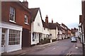
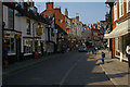

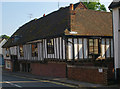
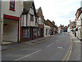

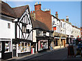
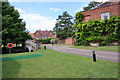

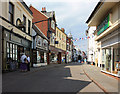

97 photos from this area
Area Information
Key information about the SG5 2BY including its size, population, and administrative classification.
- Area Type
- Postcode
- Area Size
- 1.4 hectares
- Population
- 2470
- Population Density
- 3019 people/km²
House Prices in SG5 2BY
19
Properties
£468,019
Average Sold Price
£305,495
Lowest Price
£760,000
Highest Price
Showing 19 properties
| Address | Type | Beds | Baths | Last Sale Price | Last Sale Date | |
|---|---|---|---|---|---|---|
| 7, Kitchen Garden Court, Old Charlton Road, Hitchin, SG5 2BY | Terraced | 5 | 2 | £742,500 | Nov 2023 | |
| 18, Kitchen Garden Court, Old Charlton Road, Hitchin, SG5 2BY | Semi-detached | 4 | 2 | £750,000 | Jul 2023 | |
| 9, Kitchen Garden Court, Old Charlton Road, Hitchin, SG5 2BY | house | - | - | £760,000 | Dec 2021 | |
| 4, Kitchen Garden Court, Old Charlton Road, Hitchin, SG5 2BY | Semi-detached | 4 | 2 | £550,000 | May 2020 | |
| 19, Kitchen Garden Court, Old Charlton Road, Hitchin, SG5 2BY | house | 4 | 2 | £630,000 | Jul 2018 | |
| 17, Kitchen Garden Court, Old Charlton Road, Hitchin, SG5 2BY | Terraced | 4 | 2 | £410,000 | May 2013 | |
| 12, Kitchen Garden Court, Old Charlton Road, Hitchin, SG5 2BY | Terraced | 4 | - | £382,000 | Nov 2012 | |
| 10, Kitchen Garden Court, Old Charlton Road, Hitchin, SG5 2BY | house | 5 | - | £450,000 | Aug 2010 | |
| 8, Kitchen Garden Court, Old Charlton Road, Hitchin, SG5 2BY | house | - | - | £485,000 | Jul 2010 | |
| 15, Kitchen Garden Court, Old Charlton Road, Hitchin, SG5 2BY | house | - | - | £315,000 | Dec 2009 |
Page 1 of 2
Energy Efficiency in SG5 2BY
Amenities
Schools
| Rank | School | Type | Entry gender | Ages |
|---|
Explore more schools in this area
Go to Schools tabDemographics
Household Size
One person
most common
Accommodation Type
Flats
most common
Tenure
58
majority
Ethnic Group
White
most common
Religion
N/A
most common
Household Composition
N/A
most common
Age
47
median
Adults (30-64 years)
most common
Household Deprivation
N/A
with no deprivation
NS-SEC
52
in Lower managerial occupations
Explore more demographic insights in this area
Go to Demographics tabPlanning
Planning Constraints
- Flood RiskPremium
- Ramsar Wetland SitesPremium
- Area of Outstanding Natural BeautyPremium
- Protected Nature ReservePremium
- Protected WoodlandPremium