Area Overview for SG4 9DY
Photos of SG4 9DY


Area Information
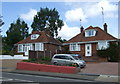
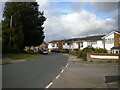
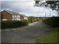
Living in SG4 9DY offers a settled existence within a specific residential cluster of 2062 people. This postcode area covers a small geographical footprint but provides a robust foundation for daily life in north Hertfordshire. You will find a community where practical convenience meets a quiet suburban rhythm, situated close to the major hubs of Hitchin and Stevenage. The area represents a stable choice for those seeking a_defined residential environment without the noise of a major town centre. Residents here experience a distinct sense of locality, surrounded by homes that foster neighbourly connections while maintaining privacy. The demographic profile suggests a mature population, meaning the streets are likely populated by families and professionals who value stability. Daily life revolves around reliable access to nearby train stations and essential retail outlets. You move through an area where the infrastructure is built to support established households rather than transient populations. The location balances accessibility to the wider county with the intimacy of a contained neighbourhood. For anyone considering buying a home here, the focus is on solid, long-term living within a well-defined boundary.
- Area Type
- Postcode
- Area Size
- Not available
- Population
- 2062
- Population Density
- 2852 people/km²
The property market in SG4 9DY is overwhelmingly characterised by permanent residency. With 88% home ownership, this area functions as a genuine owner-occupied market rather than a rental hub. You will find that the housing stock is dominated by houses, aligning with the preferences of the mature demographic living here. This concentration of freehold properties implies that the local estate market sees movers who have either stayed for decades or are choosing this specific location for retirement. There is almost no footprint of flats or purpose-built apartments within this postcode, reinforcing the traditional suburban character. When you look at homes in SG4 9DY, you are entering a market where buyers typically intend to remain for an extended period. The high ownership percentage also suggests lower strata-related costs and a simpler legal process for purchase compared to shared ownership developments. This area appeals to those who want a house that they can modify and settle into without the constraints of leasehold agreements. The immediate surroundings likely reflect similar patterns, as the housing style is uniform and residential throughout. Your search for a home here should focus on the specific merits of individual dwellings rather than building management structures.
House Prices in SG4 9DY
No properties found in this postcode.
Energy Efficiency in SG4 9DY
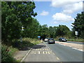
Your lifestyle in SG4 9DY centres on convenient access to established retail and transport hubs. Within practical reach, you have five key shopping destinations including M&S Oakfield Hitchin BP, Asda Hitchin, and M&S Hitchin SF. These supermarkets provide everything from daily groceries to furniture, meaning you rarely need to travel far for essentials. For commuting, five railway stations serve the area, with Hitchin, Letchworth, and Stevenage offering regular links to the wider network. Hitchin Railway Station is immediately accessible, providing a short journey to the city for work or leisure. You can walk to Letchworth and Stevenage stations for reach to even more destinations without needing a personal vehicle. This amenity density means your day-to-day life is efficient and requires minimal planning. Local shopping is just moments away, combining convenience with the ability to manage household budgets effectively. The presence of these major retailers ensures that family shopping trips and errands can be handled with ease. You enjoy the freedom of choosing between the larger Super Centre options at Asda and the smaller local units at MHS Owlfield Hitchin BP depending on your needs.
Amenities
Schools
| Rank | School | Type | Entry gender | Ages |
|---|
Explore more schools in this area
Go to Schools tabDemographics
The community in SG4 9DY is defined by its mature character, with a median age of 47 years. The most common age range for residents falls between 30 and 64 years, indicating a population of working adults and those approaching retirement. This age profile creates a neighbourhood where stability is the norm rather than the exception. Home ownership is a central feature of daily life, with 88% of residents owning their property outright or with a mortgage. This high ownership rate suggests strong financial stability within the community and a deep sense of investment in the local area. There is no significant section of the population living in rented accommodation, which often leads to lower tenant turnover and more established local traditions. The accommodation stock consists primarily of houses, catering to families and those seeking single-family living arrangements over flats or apartments. The predominant ethnic group is White, reflecting the established nature of the neighbourhood. This demographic makeup means you are joining a community where life decisions and long-term plans are already firmly rooted. The lack of transient housing ensures that local services and social circles remain consistent year after year.
Household Size
Accommodation Type
Tenure
Ethnic Group
Religion
Household Composition
Age
Household Deprivation
NS-SEC
Explore more demographic insights in this area
Go to Demographics tabPlanning
Planning Constraints
- Flood RiskPremium
- Ramsar Wetland SitesPremium
- Area of Outstanding Natural BeautyPremium
- Protected Nature ReservePremium
- Protected WoodlandPremium