Area Overview for SG3 6TJ
Photos of SG3 6TJ


Area Information
Datchworth sits as a quiet settlement within the Hertfordshire countryside, defined by postcode SG3 6TJ. This specific area covers a small residential cluster inhabited by 2,352 people. The population density averages 187 people per square kilometre, creating a low-density environment typical of rural England. You will find traditional cottages and green spaces here, rooted in a history that dates back to a Saxon lord named Daecca around 700 AD. The village green remains a central feature, hosting two historic pubs and local sports activities. Living in SG3 6TJ means embracing a lifestyle detached from the rush of major cities, yet kept close to towns like Hertford, Stevenage, and Welwyn Garden City. The site follows a Roman road from St Albans to Puckeridge, adding historical weight to the daily commute or leisurely walk. You move through an area where the past is visibly preserved alongside modern housing needs. The character of SG3 6TJ is shaped by this medieval foundation, offering a sense of longevity and stability that defines the local atmosphere for current residents.
- Area Type
- Postcode
- Area Size
- Not available
- Population
- 2352
- Population Density
- 187 people/km²
Homes in SG3 6TJ are dominated by the house format, with no data suggesting the presence of apartment blocks or high-rise developments. This indicates a market focused on standalone residences with private gardens and land. Owner occupancy reaches a high level at 78 per cent, meaning the majority of residents pay off their mortgages rather than renting. You are entering a zone where buying offers more stability than renting, as most neighbours have a permanent stake in their properties. The housing stock consists of traditional cottages and rural dwellings fitting the character of Datchworth. Small residential clusters like this often see limited immediate supply, where existing homes hold value based on their rural setting and historical significance. Buyers looking at SG3 6TJ should expect a landscape defined by individual properties rather than shared corridors or communal blocks. The dominance of houses and owners creates a secure environment where property sales reflect long-term investment strategies.
House Prices in SG3 6TJ
No properties found in this postcode.
Energy Efficiency in SG3 6TJ
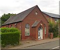
Residents of SG3 6TJ enjoy a range of services positioned within practical reach without needing to drive far. Retail options include five local shops, notably the Tesco Woolmer, Co-op Knebworth, and the Budgens store in Watton at. These venues cover essential grocery needs and daily shopping comfortably. For rail users, five stations serve the corridor, including Watton, Knebworth Railway Station, and Welwyn North Railway Station, facilitating connections to wider Hertfordshire. The village green anchors social activity, hosting two historic pubs at The Plough and The Tilbury alongside a local sports club. Living in SG3 6TJ means balancing rural quiet with access to named cafes, supermarkets, and transport hubs. The amenities listed provide self-sufficiency for week-to-week living while keeping larger retail and travel options minutes away. You find a convenient blend of village traditions and modern commercial access.
Amenities
Schools
Families living in SG3 6TJ have access to two named educational institutions within practical reach. Aston St Mary's Church of England Aided Primary School holds an outstanding Ofsted rating, marking it as a top-tier facility for young children. All Saints Church of England Voluntary Aided Primary School, Datchworth, carries a good Ofsted rating, providing a second reputable option for primary education. Both schools are confined to the primary sector, meaning there are no secondary schools or colleges listed in the immediate vicinity for this postcode. This arrangement suggests that older children likely travel to larger towns in Hertfordshire for further education. The presence of schools rated good and outstanding indicates a solid educational foundation for local residents. You do not find comprehensive schools or academies directly attached to SG3 6TJ, but the quality of the primary options is clearly established by the regulatory bodies.
| Rank | School | Type | Entry gender | Ages |
|---|
Explore more schools in this area
Go to Schools tabDemographics
The community in SG3 6TJ is predominantly occupied by adults aged between 30 and 64 years. This age range represents the most common demographic in the area. You will find that 78 per cent of residents are homeowners, indicating a settled community with strong local roots. Houses form the primary accommodation type, reflecting the elimination of flat living in this specific cluster. The predominant ethnic group within SG3 6TJ is White, aligning with the broader demographic profile of rural Hertfordshire. Higher home ownership levels often correlate with greater investment in the neighbourhood and lower mobility rates. The population composition suggests families and established individuals rather than transient workers or students. These specific figures depict a stable village life where long-term residents shape the local culture. The lack of significant younger adult presence or student populations means the pace of life remains considered rather than hurried.
Household Size
Accommodation Type
Tenure
Ethnic Group
Religion
Household Composition
Age
Household Deprivation
NS-SEC
Explore more demographic insights in this area
Go to Demographics tabPlanning
Planning Constraints
- Flood RiskPremium
- Ramsar Wetland SitesPremium
- Area of Outstanding Natural BeautyPremium
- Protected Nature ReservePremium
- Protected WoodlandPremium